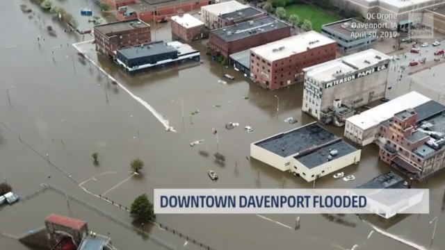
Downtown Davenport, Iowa flooded after HESCO barriers in the region failed sometime around 3:30 p.m. local time as the Mississippi River rose to nearly 6.71m, with no injuries reported but authorities and volunteers having to rescue some people by boat, the Quad-City Times reported on Tuesday.
KWWL Storm Track 7 tweeted that after flood barriers broke, it took only around 1o to 15 minutes for the area to fill with water.
A portion of the Mississippi River flood barrier failed today in downtown Davenport leading to scenes like this.#flooding pic.twitter.com/xpt8OcOhAd
— WeatherNation (@WeatherNation) May 1, 2019
Photos from the @wqad live blog: Take a look at these images coming out of downtown Davenport right now.
A flood wall breach = dangerous flooding. Water creeping past 2nd Street
Crews are on the scene preforming rescues by boat.https://t.co/iIQQNAeaET pic.twitter.com/Eu7Xo4RjNc
— Ryan Jenkins (@RyanJenkins_TV) April 30, 2019
The intersection of 2nd and Pershing in Davenport, where a barrier collapsed, sending floodwaters surging further into downtown. pic.twitter.com/XpOudg11oT
— Ed Tibbetts (@EdTibbetts) April 30, 2019
Scott County Emergency Management Director David Donovan told Weather.com that “The temporary flood protection levee that they put in place failed this afternoon and it’s inundating a portion of downtown Davenport” spanning about four blocks. He added that water had reached six feet in some areas, with fire rescue crews going door to door and local businesses forced to shutter.
A National Weather Service flash flood emergency warning was lifted at around 7:30 PM local time, Weather.com added, but the agency said that was not because the waters were receding but because they had stopped rising rapidly.
Officials don’t expect the flooding to expand beyond the current area unless there is heavy rainfall, according to the Associated Press, but heavy rain in “Iowa, Illinois and Missouri, as well as sections of Kansas, Oklahoma and Arkansas” is expected to continue through Wednesday. Governor Kim Reynolds also tweeted that she believed flooding in the region could worsen tomorrow, and local businesses are preparing for the worst.
Flooding will likely worsen tomorrow so please remain vigilant, follow directions from local officials and law enforcement, and be prepared to evacuate if necessary. (2/3)
— Gov. Kim Reynolds (@IAGovernor) April 30, 2019
It is additionally possible that sewers will flood, driving their contents above ground level and posing a health hazard to anyone that comes into contact with the water.
As the Des Moines Register noted, Iowa has already been seriously affected by flooding this year (including the so-called “bomb cyclone” that swept across the central U.S. in March) and concerns about Mississippi River levels “driven by snowmelt and heavy rain, has been high for weeks, but the danger spiked again this week after easing somewhat earlier in April.”
The river is expected to crest at 6.80m at the Rock Island, Illinois, Lock and Dam on Wednesday afternoon, just short of the 22.63 record in July 1993, the paper added.
“This is exactly what ’93 looked like,” WQAD-TV meteorologist Eric Sorensen said, according to the Register. “This is really something, you guys. I’m at a loss. All of our fighting to keep that river back. Everybody’s businesses here are going to go. This is a great place. Man, Davenport is a great place. … This is just something.”
According to the Quad-City Times, “Wednesday marks the 39th day of continuous flooding here,” making this the longest flood on record.
“Because so much of the Midwest experienced heavy rain last fall, followed by the wettest winter on record, the soils remain saturated over a wide area,” Weather.com meteorologist Bob Henson wrote. “It won’t take a great deal of rain to trigger additional flooding as the spring unfolds.”