The wall of wind-driven ocean that accompanies a hurricane is called a “surge” for a reason: This isn’t a gentle rising of the water level, it’s violent and destructive — sometimes more so than the hurricane’s winds. This hurricane season, for the first time, the National Hurricane Center will be testing a prototype storm surge warning system which it hopes will be fully operational in 2017.
The National Weather Service already issues watches and warnings for hurricanes and tropical storms, but those are based on the odds of a storm making landfall with strong enough winds to qualify it for a place on the Saffir-Simpson scale — the familiar Category 1 to Category 5 ranking system for hurricanes. The Saffir-Simpson scale is based entirely on wind speed; any storm with winds of 74 to 95 miles per hour is a tropical storm, and any storm with winds over 95 miles per hour is a hurricane.
But high winds are only one of the ways a hurricane can wreck everything in its path. Hurricane winds push water into a big pile ahead of the storm, and as the hurricane moves toward landfall, it drives the sea toward the shore as well.
Once the storm surge warning is in place, the new system will give the National Weather Service the ability to issue storm surge watches and warnings to coastal areas threatened by approaching hurricanes. That’s very good news for people who live there. Right now, the Saffir-Simpson scale doesn’t convey any information about potential storm surges at all.
A Lesson From Hurricane Ike
When Hurricane Ike made landfall on Galveston Island, Texas in 2008, it was only a Category 2 storm, but it packed a devastating storm surge. The storm’s sheer size meant that 12 to 16 feet of water swept across Bolivar Peninsula, destroying almost 90 per cent of the homes in the communities there.
Then the storm surge picked up the broken remains of many of those homes and washed them across the eastern arm of the bay, where 10 to 20 feet of water, laden with debris from Bolivar Peninsula, washed over the cattle-grazing land. When the water receded, it left lines of debris that stretched for miles across the muddy cattle fields.
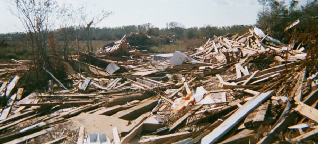
Chambers County, TX after Hurricane Ike, 2008 Kiona Smith-Strickland
Meteorologists later said that Ike’s storm surge had been closer to what they would expect from a Category 4 storm, but the fact is that the Saffir-Simpson scale just doesn’t give forecasters, emergency managers, or coastal residents a good way to predict storm surge. It had been on the table since at least 2005, but Ike drew attention to the need for a better watch and warning system for storm surges.
“Prior to 2004/2005, it seemed like the focus was on the wind hazard (e.g., Hurricane Andrew in 1992) and the inland rainfall hazard (Dennis and Floyd, 1999),” Phil Klotzbach of Colorado State University’s Tropical Meteorology Project told Gizmodo in an email. After Hurricane Katrina in 2005, focus began to shift to storm surge predictions and warnings.
“We knew, more than 10 years ago, that there was a need for a storm surge watch and warning out there,” Brian Zachry, PhD, meteorologist and storm surge expert at the National Hurricane Center, told Gizmodo. Developing a way to predict storm surge and issue advisories about it would require time, effort, and resources, however. Then Ike, in 2008, drove home the need for storm surge watches and warnings.
Zachry explained, “About 24 hours before landfall, long before the winds started coming up to hurricane strength, the storm surge was already inundating Bolivar Peninsula and Galveston Island. So we really didn’t, at that point, have a watch and warning that we could put out well ahead of time, because the winds weren’t even there yet.”
In 2012, Hurricane Sandy provided another impetus to develop a warning system for storm surge, separate from the Saffir-Simpson scale based on wind speed. After the storm, the National Hurricane Center received supplemental funding to work on the problem.
A Prototype Warning System
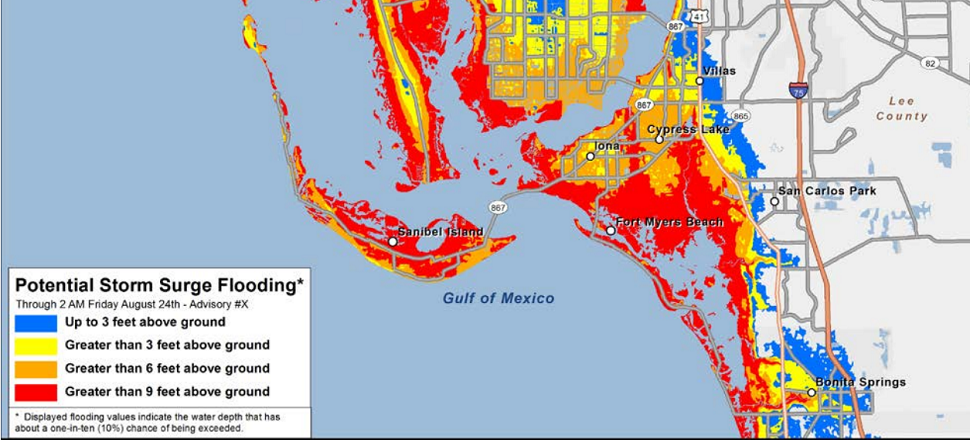
Last year, as Hurricane Arthur approached the North Carolina coast, the National Hurricane Center released a prototype of a potential storm surge flooding map. The map showed how much flooding forecasters expected to see along the coastline, in three-foot increments. It wasn’t a formal watch or warning, but it gave local governments and residents a much clearer idea of what was coming.
The National Hurricane Center creates the maps based on probabilistic data, taking into account every possible change in direction, size, speed, or intensity before the storm makes landfall. These can be created for each storm, said Zachry. “We’re doing potentially five to ten thousand different storm surge simulations to come up with different possible scenarios.”
The maps were a good tool, especially for the public, according to Klotzbach. “I also really like that they have the new surge maps displayed relative to ground level at your location. That is a simple benchmark that the general public can easily understand,” he said.
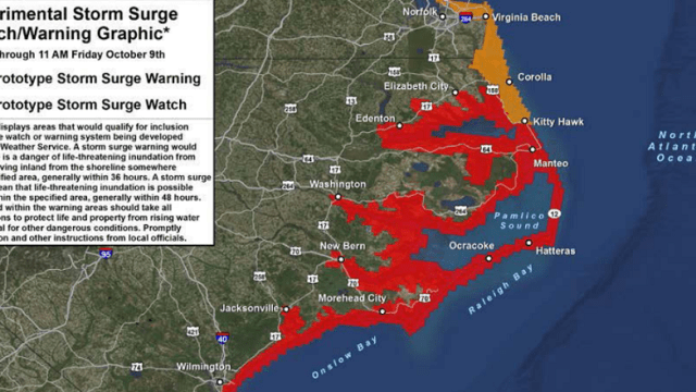
This year, the National Hurricane Center is testing the prototype of a system of watches and warnings. “What that shows is areas that have a signficant risk of life-threatening storm surge from a tropical cyclone,” said Zachry.
The watch and warning map will be available on the National Hurricane Center’s website, where it will be accessible to the public, media, and local weather forecasters. Zachry said that it may be picked up by local news stations or even the Weather Channel, which used the prototype flooding map last year during Hurricane Arthur. It won’t yet be an official National Weather Service warning, though.
This season, Zachry and his colleagues hope to get feedback from local forecasters and emergency managers. “We can test how we would create a watch and warning for past storms. We’ve done that many, many times now — we’ve worked on that a lot. But we really need to go through a season, talk with emergency managers and local weather forecasters, to see how this watch and warning for storm surge will work during a storm,” he said. “The only way to get feedback is during a season.”
Based on this year’s feedback, the National Hurricane Center will make improvements and release an updated prototype next year. They will get make more improvements, and by 2017, the National Weather Service will begin issuing official storm surge watches and warnings, accompanied by flood prediction maps.
And hopefully, coastal residents will heed those warnings.