In December 1968, the Apollo 8 mission carried three astronauts on a trip around the Moon — further than anyone had ever gone before. For a mission that far, navigation was the biggest unknown factor. Had the spacecraft’s velocity been even a bit off, it would’ve crashed onto the far side of the Moon.
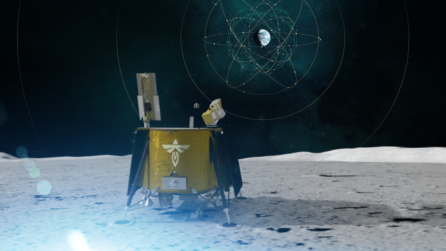
Fast forward to today, and in consideration of NASA’s upcoming Artemis missions to the Moon, the space agency is once again thinking about navigation and the issue of safety. To that end, NASA is looking to test a new lunar navigation system that uses signals from Earth’s Global Navigation Satellite System (GNSS), but in the vicinity of the Moon. That’s never been done before. NASA is preparing to send this experimental payload to the Moon, which will be delivered by Firefly Aerospace’s Blue Ghost lander no earlier than 2024, according to NASA.
GNSS refers to satellite constellations that transmit positioning, timing and navigation signals from space to receivers on Earth. The most commonly used GNSS system is GPS, which is operated by the U.S. Space Force.
NASA’s Lunar GNSS Receiver Experiment (LuGRE), developed in partnership with the Italian Space Agency (ASI), will attempt to calculate the first-ever location fixes during a trip to the Moon, as well as on the lunar surface. LuGRE will receive signals from both GPS and Europe’s own GNSS constellation, Galileo, during its journey to the Moon. The receiver will also conduct navigation experiments at different altitudes and while in orbit around the Moon.
After landing on the Moon with Blue Ghost, the LuGRE receiver will unfurl its antenna and collect data for 12 days, or possibly longer. The gathered data will then be beamed down to Earth and used to develop operational lunar GNSS systems for future missions to the Moon.
“In this case, we are pushing the envelope of what GNSS was intended to do — that is, expanding the reach of systems built to provide services to terrestrial, aviation, and maritime users to also include the fast growing space sector,” J.J. Miller, deputy director of policy and strategic communications for NASA’s Space Communications and Navigation (SCaN) program, said in a statement. “This will vastly improve the precision and resilience of what was available during the Apollo missions, and allow for more flexible equipage and operational scenarios.”
LuGRE is a part of ongoing efforts to expand the high-altitude capabilities of GNSS, a system that space missions have long relied on for navigation and timekeeping. In recent years, the system’s reach has expanded to include missions that are between approximately 2,896 kms and 35,405 km in altitude. In 2016, NASA’s Magnetospheric Multiscale Mission used GPS at a record-breaking altitude of 70,000 km above the Earth.
“LuGRE is the latest effort in a long line of missions designed to expand high-altitude GNSS capabilities,” Fabio Dovis, LuGRE co-principal investigator at the Italian Space Agency, said in a statement. “We’ve developed a cutting-edge experiment that will serve as the foundation for operational GNSS systems at the Moon.”