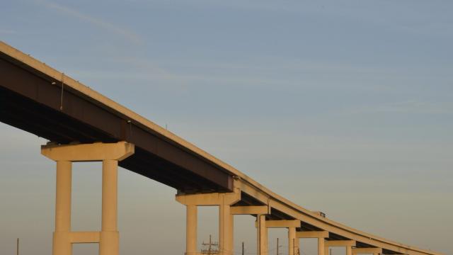
The sun was about to set at the Leeville boat launch when a family began packing up their car with redfish they had caught just an hour prior. Above us was LA-1, an elevated highway nicknamed the “Gateway to the Gulf” because it is the only connector between what can still be considered mainland Louisiana to Grand Isle, the state’s last inhabited barrier island. Noise from the trucks transporting materials from Port Fourchon, a major offshore oil hub where 90% of the Gulf’s production platforms and drilling rigs are serviced, rumbled above us while boats traversed the patchwork of eroded marsh.
I started photographing the architecture and landscape of South Louisiana in 2014, long after the fossil fuel industry’s hold on the region began. Most of my work focuses on the infrastructure of this unique area as a means to convey how we’ve altered the land — and the unequal protection this infrastructure provides. When Hurricane Ida made landfall, it did so at that marsh I was photographing under LA-1.
While the storm itself spun up in a manner of days, its impacts were decades in the making. With peak wind gusts of 277 km/h recorded and 4 metres of storm surge at Port Fourchon, Ida caused catastrophic damage. That includes the community of Grand Isle, where the mayor said 100% of all structures on the island were damaged with 40% destroyed or nearly destroyed.
Louisiana’s relationship with the fossil fuel industry is pervasive; there is no aspect of life that is untouched by the years of exploitation and extraction these companies have pursued. Wetlands have historically served as a natural hurricane protection system. But in order to build and service pipelines, companies dig canals through the marshes. Over time, saltwater intrusion erodes this habitat and becomes open water. At the same time, the oil and gas burned in places far from Louisiana’s disappearing coast have pushed sea levels higher, creating a squeeze on the region.
On average, the Gulf of Mexico swallows a football field worth of Louisiana’s coastline every 100 minutes. By the time Ida’s storm surge reached the Leeville boat launch on August 29, the state had already lost nearly 3,220 kilometres of land, an area approximately the size of the state of Delaware. Comprehending the massive scale of environmental degradation can be abstract, but for those who have lived here for generations, the changes are linked to specific memories and familial history.
The sinking of so much land allowed storm surge to penetrate farther inland, causing more damage to coastal communities. But while Ida was a singular event, the damage wrought by disappearing land has altered life in shrinking coastal Louisiana.
In South Louisiana, the degradation wrought by the fossil fuel industry has already led to the assisted migration of some communities to higher ground. That could test the bonds of communities and affect their relationship to the place they formerly called home.
It raises questions about if migration — forced or otherwise — away from the coast is feasible at the scale needed in the coming century as the climate crisis puts more and more communities on the frontline. Ida is the latest in a series of storms that have hit the U.S. and elsewhere to demonstrate the futility of the argument to “just leave” when there is no place untouched by the climate emergency created by burning fossil fuels.
The deterioration of Louisiana’s coast is also due in part to the leveeing of the Mississippi River and the attempt to control its natural course. In response to the Great Flood of 1927 which inundated 69,930 square kilometres across 12 states, U.S. Congress essentially nationalised flood control along the river and granted the work of doing so to the Army Corps of Engineers.
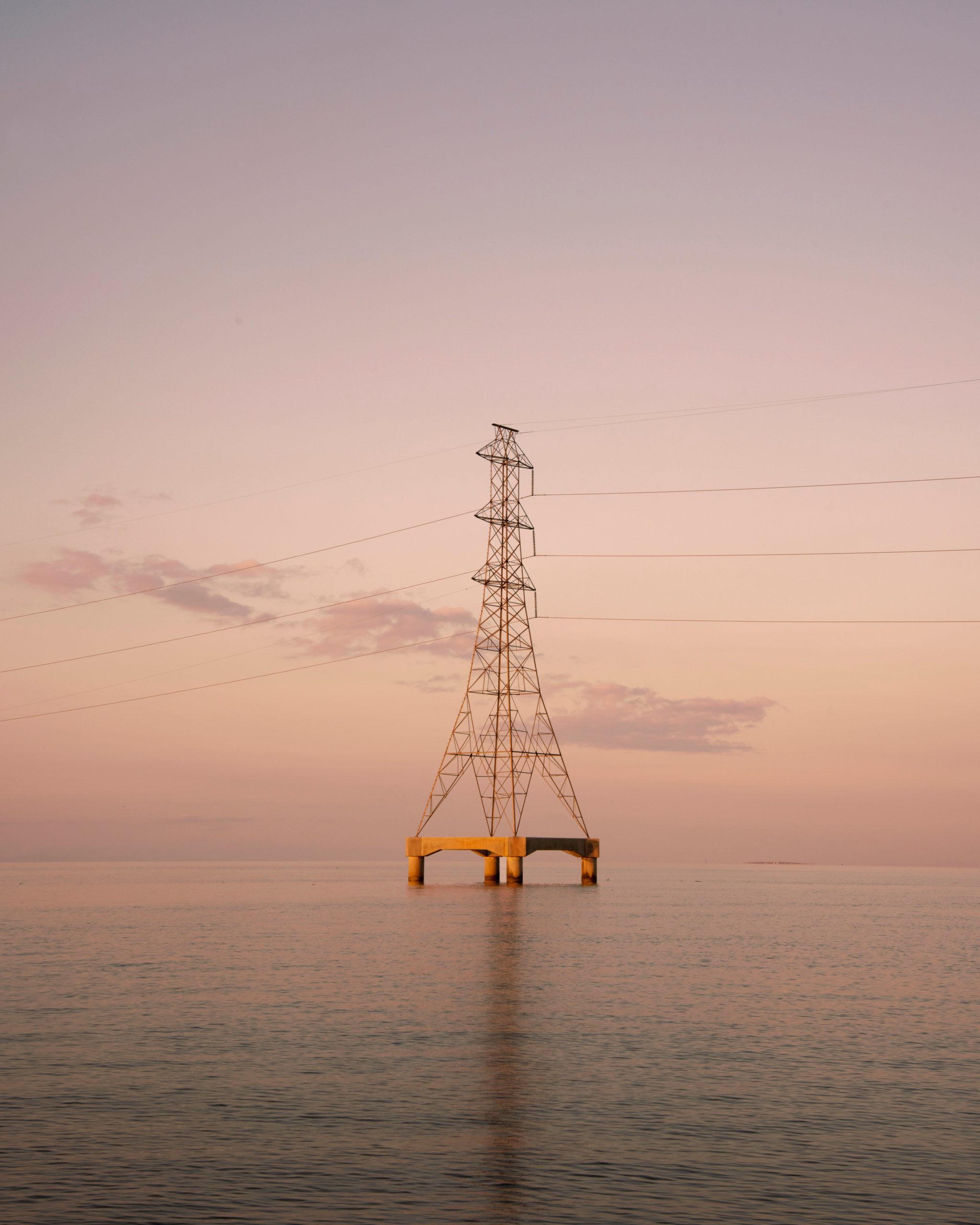
Looking at the fractured landscape of Plaquemines Parish which straddles the Mississippi River as a sliver on both sides until it reaches the Gulf of Mexico, the land loss crisis is visibly due in part to human engineering. Most of my work focuses on the infrastructure of South Louisiana as a means to convey how we’ve altered the land and the unequal distribution of protection this infrastructure provides.
Hurricane Ida tested the levee system surrounding New Orleans and its suburbs, demonstrating that ambitious investments in infrastructure actually work. However, the system grows weaker with each square mile of coast lost to the Gulf of Mexico, pushing the water at the city’s gates higher and higher.
Meanwhile, communities like Houma, Cocodrie, and Chauvin — all places hit hard by Ida — have been essentially treated as buffer zones as land disappears around them. That risks creating the perception that these places are less important or worthy of recovery assistance than places like New Orleans, when the truth is that the future of South Louisiana is dependent on the health of the ecosystems and communities on the edge of the Gulf.
Driving between New Orleans to Houma on Highway 90, you’ll see billboards sponsored by Shell that tout “The Rhythm of Louisiana” against a backdrop of refineries that line the heavily concentrated petrochemical corridor of the Mississippi River. The 140-kilometre stretch of river from Baton Rouge to New Orleans has been called Cancer Alley and treated as a sacrifice zone by the fossil fuel industry by exposing residents to some of the most polluted air, water, and soil in the nation. These same communities, like LaPlace in St. John the Baptist Parish, were also hit hard by Ida, compounding the impacts of the climate crisis.
Nearly 190,000 households in Southeast Louisiana are still in the dark and will continue to be for what looks like the next several weeks ahead. But when the lights come on, a new reality will set in, one that makes it hard to ignore the failures of our government to prioritise the health and safety of the people of South Louisiana over the profits of Big Oil.
Today, donate to the organisations helping the thousands without food, water, and electricity because your community could be next. In the coming weeks, continue those efforts when the major news outlets have moved on to cover the next climate emergency; there are no buffer zones in the world we now live in.
Virginia Hanusik is an artist whose projects explore the relationship between landscape, culture, and the built environment. Her work has been exhibited internationally, featured in The New Yorker, National Geographic, British Journal of Photography, and Oxford American among others, and supported by the Pulitzer Centre, Graham Foundation, and Mellon Foundation.