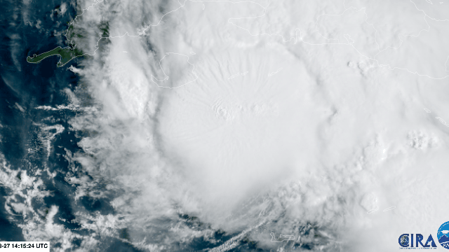
Cuba is currently bearing the brunt of Tropical Storm Ida, with heavy rain and gusty winds. But what’s happening there is unfortunately a warmup for what could be an explosive few days for the storm.
Ida is expected to pass over the western tip of Cuba and emerge into the Gulf of Mexico on Friday night. If you were baking a cake for a storm to develop into a monster, all the ingredients will be set up for that to happen over the weekend as Ida charts a course toward the Gulf Coast. Ida is expected to undergo rapid intensification and be a Category 3 beast when it comes ashore, likely somewhere in Louisiana, on Sunday night, due to a few major factors. If you live there, I cannot stress enough how important it is to pay attention to the forecast and local officials.
The Gulf Is Unusually Warm to an Unusually Deep Level
On Wednesday, Mississippi State hurricane researcher Kim Wood tweeted a graphic showing that the waters in Ida’s forecasted path are upwards of 30 degrees Celsius not just at the surface but up to 131 feet (40 meters) down. The data comes courtesy of Argo floats in the Gulf (they can be found bobbing in oceans all over the world as well), not models.
This is significant for two reasons. One, water that hot is crucial for hurricanes to rapidly intensify, which is defined as an increase in the maximum winds of at least 56 km/h in a 24-hour period. Two, the depth of the heat is simply astounding and ensures Ida will have an essentially limitless supply of energy from the ocean to power up.
“As the storm moves overhead, the winds churn up the water,” Wood said in a phone call. “It’s called upwelling. It’ll bring water from below to the surface. But when you see the warm water to 40-plus metres depth, that means that the water that comes up from below is a similar temperature to what the original sea surface temperatures have been, thus continuing to provide energy to the storm.”
Wood said that the heat itself isn’t super uncommon because sometimes the Loop Current that circulates through the Gulf gets “pinched off sort of creating this blob of additional heat.” What is rare is the depth and the fact that a hurricane is passing over at the same time.
The Atmosphere Is Also Ready to Help Ida Grow
Hot water alone isn’t enough for a hurricane to rapidly intensify (though it certainly helps). The atmosphere also has to cooperate, and unfortunately, that’s exactly what it’s doing. Upper-level winds are very slack, creating what meteorologists call low wind shear. That allows Ida to stand up tall and efficiently funnel all that energy from the ocean into the atmosphere.
Large-scale patterns like La Niña, cooler than normal waters in the eastern tropical Pacific, can help usher in lower shear across the Atlantic. While there’s a La Niña Watch in place for the summer and fall, Wood said daily weather is likely exerting a greater role here. The slack atmosphere will allow Ida’s wind field to expand hundreds of miles wide, which is more bad news. More widespread wind allows storms to scoop up more water and push it ashore. You can see the effect if you run your pinky along the surface of the tub full of water and then repeat the same experiment with your entire arm.
Climate Change and Ocean Heat Can’t Be Untangled
The relationship between heat and carbon pollution is the clearest manifestation of the climate crisis. That’s true on land, and it’s true on oceans. Marine heat waves have become more common and intense. The impacts are manifold, including increasing ocean stratification and destroying coral reefs. There are growing signs the heat is also contributing to more fierce hurricanes.
“You need to meet certain thresholds for rapid intensification to be possible. Those thresholds aren’t changing, but the background is,” Wood said, in what is perhaps the best distillation of the relationship between climate change and storms I have heard.
In recent years, there’s been no shortage of rapidly intensifying storms in the Atlantic, among them nightmares like Maria, Dorian, Michael, Eta, and more. Ida is perfectly poised to join their ranks, and that’s a huge concern for the Gulf Coast.
The National Hurricane Centre currently has Ida coming ashore as a major hurricane with winds of 195 km/h somewhere along the Louisiana coast on Sunday night. Storm surge up to 3.4 metres in height will rush ashore. The coasts as well as inland areas will also be inundated with torrential rain that will trigger flash flooding. This is shaping up to be a very serious situation.
“Everyone who’s trying to issue messages wants you to stay safe,” Wood said. “We are giving you this information not for hype, not for scaring. We just want to take whatever steps you need to be safe.”