Using radar and other ice-penetrating instruments, scientists have detected a “fossil lakebed” preserved beneath the Greenland ice sheet, in what is the first discovery of its kind.
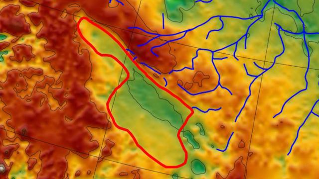
Now a basin smothered by a gigantic sheet of ice, this former lake once measured 7,100 square kilometres in size, which is an area comparable to Rhode Island and Delaware combined, according to a Columbia University press release. In some places it got as deep as 250 metres, and it was fed by more than a dozen streams. Doesn’t sound very Greenland-ish today, but this is how the island likely looked millions of years ago.
Eventually, however — and we’re not entirely sure when — this lake got covered in ice, never to see daylight ever again. New research published in Earth and Planetary Science Letters shows the lakebed is now buried beneath 1.8 kilometres of ice. The water that once coursed through this ancient basin is probably long gone, smeared away by the encroaching ice sheet, but the lake’s sediments have remained in place.
Scientists have discovered subglacial lakes before, in both Greenland and Antarctica. The difference here is that the newly discovered fossil lakebed contains no liquid water and it’s located on Greenland’s rocky surface. Such a thing has never been discovered before, according to the press release.
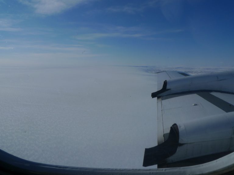
The data used to make the discovery was gathered by NASA’s Operation IceBridge, which involves low altitude surveys of Greenland’s ice sheet using ice-penetrating radar and instruments capable of measuring gravity and magnetic anomalies. Radar allowed scientists to create a topographic map of the Earth’s surface beneath the ice sheet, revealing the basin. Gravity measurements showed that material in the basin is less dense than what’s found in the surrounding rock, which is hard and metamorphic. And because sediments are less magnetic than solid rock, the researchers were able to map the depth of the sediments lying in the basin.
The data revealed that the ancient lakebed, which is located in northwest Greenland, once featured water depths between 50 to 250 metres. The layer of sediment was found to be 1.2 kilometres thick, a considerable depth of infill that likely accumulated over the course of hundreds of thousands of years — and possibly millions of years — prior to Greenland’s glacial era. Topographical features allowed the team to identify at least 18 former stream beds that once trickled into the lake along its northern shore. A possible outlet stream was also spotted to the south.
In the press release, Guy Paxman, a postdoctoral researcher at Columbia University’s Lamont-Doherty Earth Observatory who led the study, said his team is still unable to date the lake, but if “we could get at those sediments, they could tell us when the ice was present or absent.” Indeed, these scientists, and probably others, would very much like to get their hands on this ancient sediment, which they would do by drilling through the ice sheet.
In addition to dating the lake and showing when the ice was and wasn’t present, sediment samples could yield signs of ancient life in the form of plant spores or other organic materials. If detected, these biosignatures would bolster theories about Greenland’s climate history, and how it once featured vast forests. As the authors write, the “subglacial landscape pre-dates extensive glaciation in Greenland,” and as a result, the “basin may contain important records of regional glacial history and palaeoclimate.”
That said, some of this will be difficult to prove, as subsurface materials have been transported far-and-wide by the ebbs and flows of glaciers.
Drilling so far down into the ice is not without precedent. Back in the 1990s, researchers pulled a 3.2-kilometre-long ice core from the Greenland ice sheet, capturing 110,000 years of history. Scientists have also had similar success drilling cores in Antarctica’s ice. And now, thanks to this new discovery, we have a tantalising new target in northwest Greenland. Let’s get drilling!
Oh, I would be remiss to not mention that amazing buried impact crater found in Greenland two years ago. Also found by ground-penetrating radar, the crater measures around 30 kilometres across, making it one of the largest asteroid craters on Earth. Some cool things lurk beneath gigantic ice sheets — we just have to look.