Category 5 Hurricane Irma is currently barrelling through the Atlantic Ocean and is now considered the strongest recorded storm in the Atlantic basin outside of the Caribbean Sea or Gulf of Mexico, the Weather Channel reports.
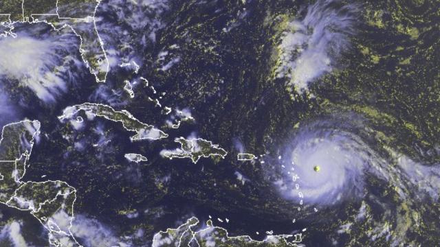
A National Oceanic and Atmospheric Administration satellite photo of Hurricane Irma. Photo: AP
“I am at a complete and utter loss for words looking at Irma’s appearance on satellite imagery,” National Hurricane Center Storm Surge Unit senior scientist Taylor Trogdon tweeted.
I am at a complete and utter loss for words looking at Irma’s appearance on satellite imagery. pic.twitter.com/B0ewFyvcSv
— Taylor Trogdon (@TTrogdon) September 5, 2017
#Irma has just generated the 2nd most Accumulated Cyclone Energy in Atlantic basin in a 24-hr period on record – trailing only Allen (1980). pic.twitter.com/ytTkIflkEM
— Philip Klotzbach (@philklotzbach) September 6, 2017
#Irma is only the 5th Atlantic basin hurricane with a peak wind speed of 185 mph or higher. pic.twitter.com/R3hZ2FG94b
— NWS Eastern Region (@NWSEastern) September 5, 2017
The storm is currently closing in on the island of Barbuda and has reached at least 298km/h wind strength, per the Weather Channel. It was less than 128km from the Leeward Islands as of around 10:15PM ET (12:15PM AEST), continuing to move west at approximately 16 to 24km/h.
“The only hurricane anywhere in the Atlantic ever known to have stronger winds was Allen (1980), at 190mph [305km/h],” Weather Underground wrote.
10:15 PM radar from Guadeloupe shows #Irma’s eyewall nearly to Barbuda. Conditions will start to go downhill in a hurry. pic.twitter.com/wWkz8mwrBs
— Alex Lamers (@AlexJLamers) September 6, 2017
According to Weather Underground, its trajectory is set to take it “near or just between Antigua and Barbuda during the predawn hours Wednesday”; it will subsequently pass St Kitts and Nevis, Anguilla, St Barthelemy and the British Virgin Islands. Later, it will “rake Puerto Rico, the Dominican Republic, Haiti and Cuba,” the Guardian wrote, before it could possibly curve north and strike parts of southern Florida this weekend.
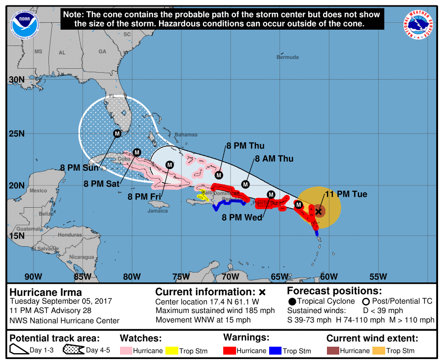
Image: National Hurricane Center
The National Hurricane Center issued a dire warning today, writing the storm could be “potentially catastrophic”. Storm surge is expected to be terrifying throughout much of Irma’s path, the NHC showed, with some regions expected to receive surges of up to 3-6m:
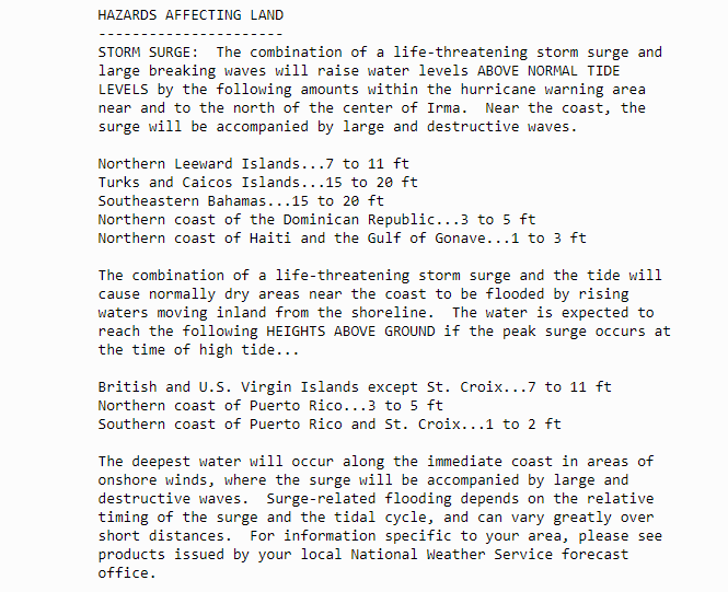
Credit: National Hurricane Center
“Anguilla, all the way toward [Antigua and] Barbuda, all the way up even toward the British Virgin Islands [are] in grave danger of an eye wall hit at [at least] 150mph [241km/h],” CNN meteorologist Chad Myers said. “That devastates the island, no matter what island it is.”
Per CNN, Irma has sent residents in the path of the storm from the Caribbean to Florida scurrying to move boats to land, reinforce residences, and scour stores for supplies. A state of emergency was declared in Florida, Puerto Rico and the US Virgin Islands, while Florida Gov Rick Scott said 7000 National Guard troops had been ordered to deploy by Friday.
“I cannot stress this enough,” Scott said. “Get prepared. Learn your evacuation zone. Listen to your locals. This storm has the potential to devastate this state. You have to take this seriously.”
Irma is the second devastating hurricane in the Atlantic in just a few weeks. In August, Hurricane Harvey slammed into southeast Texas, killing at least 50 people, displacing an estimated million others, and damaging at least 200,000 homes in a rampage which may reach $US180 billion ($225 billion) in damage.
As the Weather Channel noted, climate change could result in hurricanes which stress the boundaries of the Category 5 rating by the end of the century, with the worst-case scenario for the Tampa Bay area featuring “maximum sustained winds of 233 mph [375km/h] with a minimum central pressure of 830 millibars, travelling parallel along Florida’s Gulf Coast, producing a devastating 36-foot [11m] storm surge”.
[Weather Channel, Weather Underground, National Hurricane Center]