Last summer, a team of geologists set out on an expedition to study Slims River in the Yukon, but when they got there, the once majestic river was nowhere to be seen. The scientists attribute the missing river to a retreating glacier, which caused a dramatic shift in the direction of water flow. It’s yet another example of climate change affecting our planet in unexpected ways.
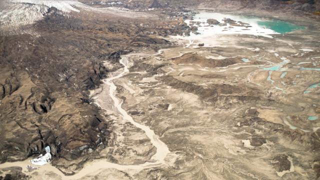
A river used to run through it. (Image: Dan Shugar/University of Washington Tacoma)
For the past century, the massive Kaskawulsh Glacier in northern Canada has been steadily retreating, but as documented in a study led by the University of Washington Tacoma, this retreat has now resulted in a rare geological phenomenon known as “river piracy”.
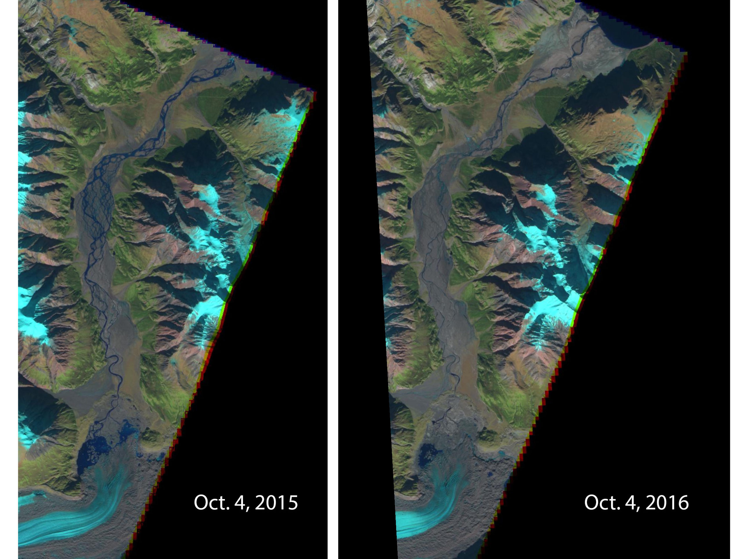
Until recently, meltwater collected near the toe, or leading tip, of the glacier. It was then directed towards the Slim River, and then into the Bering Sea. But thanks to rising temperatures, the glacier has retreated to such an extent that meltwater is now flowing towards the Kaskaulsh River and into the Gulf of Alaska.
“Geologists have seen river piracy, but nobody to our knowledge has documented it happening in our lifetimes,” noted lead author Dan Shugar, a geoscientist at the University of Washington Tacoma, in a statement. “People had looked at the geological record thousands or millions of years ago — not the 21st century, where it’s happening under our noses.”

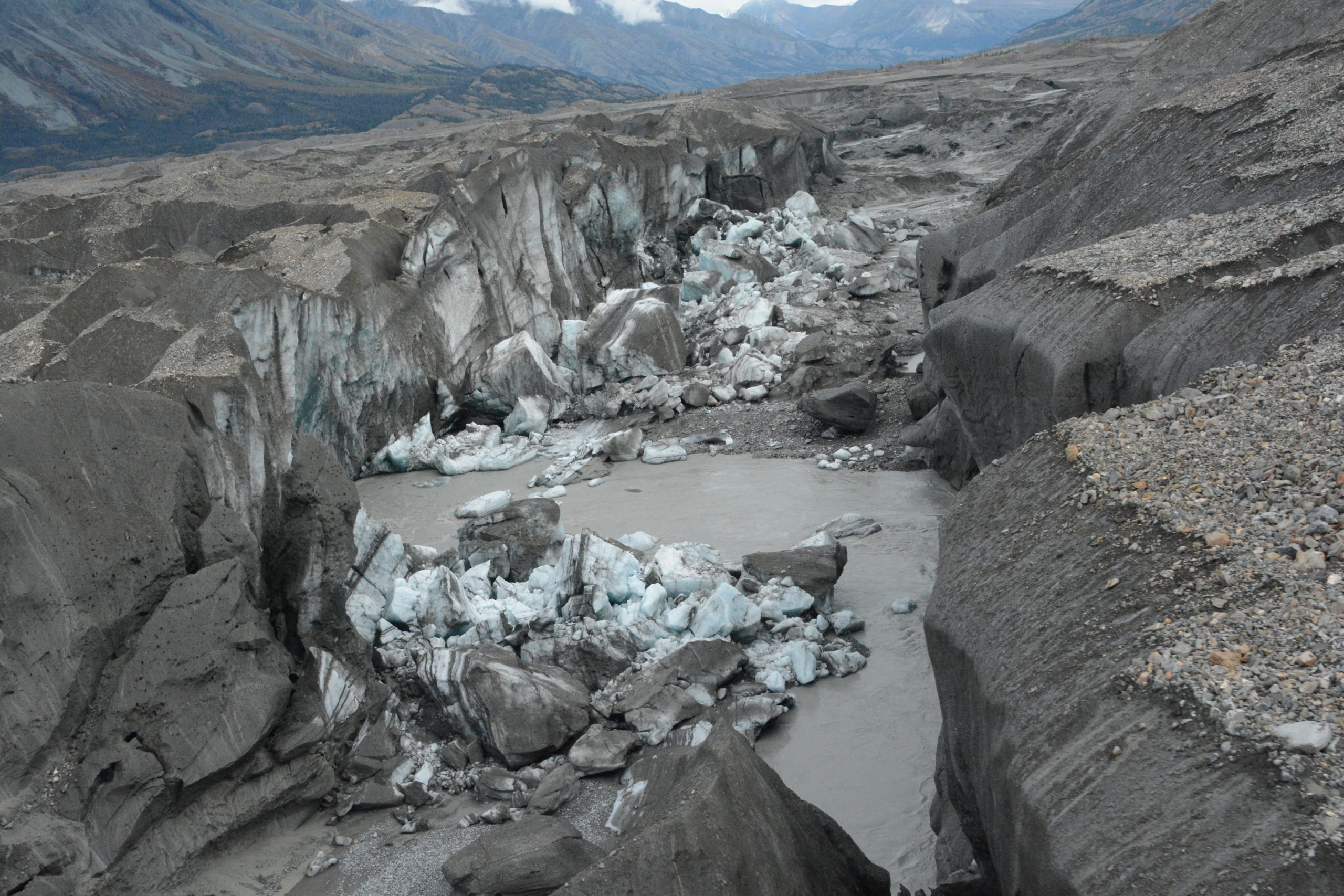
The ice-walled canyon at the terminus of the Kaskawulsh Glacier, with recently collapsed ice blocks. This canyon now carries almost all meltwater from the toe of the glacier down the Kaskawulsh Valley and toward the Gulf of Alaska. (Credit: Jim Best/University of Illinois)
Shugar and his team first came across this river theft in August 2016, when they arrived at the banks of the Slims to make observations. “There was barely any flow whatsoever,” he said. “It was essentially a long, skinny lake.” Gauges set along the river indicated an abrupt drop over four days from 26 to 29 May 2016.
Without a river to study, the researchers did the next logical thing, which was to document the geological changes to the region. The team used space-based images and an aerial drone to create a detailed elevation model, showing recent changes to the Kaskawulsh Glacier, the newly exposed region, and the missing river. The details of this survey now appear in the journal Nature Geoscience.
“For the last 300 years, Slims River flowed out to the Bering Sea, and the smaller Kaskawulsh River flowed to the Gulf of Alaska. What we found was the glacial lake that fed Slims River had actually changed its outlet,” Shugar explained. “A 30-meter (100-foot) canyon had been carved through the terminus [the outer edge] of the glacier. Meltwater was flowing through that canyon from one lake into another glacial lake, almost like when you see champagne poured into glasses that are stacked in a pyramid.”

Satellite images show a dramatic drop in the Slims River’s flow. The receding toe of Kaskawulsh Glacier is seen at the bottom. Kluane Lake can be seen at the top of the 2016 image. Water now flows east and then south via the Kaskawulsh River. (Image: ESA)
The absence of flow along this river has affected the local landscape, wildlife and communities. The Slims river used to cross the Alaska Highway, and its banks were once a popular hiking route. With the riverbed exposed, Dall sheep are now making their way down from a national park to eat the vegetation that now grows there, wandering into territory in which they can be legally hunted. The nearby Kluane Lake — the largest lake contained entirely within the Yukon — is no longer being replenished by the river, and dropped about 1m between spring and summer of 2016. Geologists say the lake will continue to drop, eventually becoming an isolated body of water cut off from any outflow. Lakefront land is already farther from shore.
It’s a peculiar event that highlights the unexpected changes wrought by a changing climate.
“So far, a lot of the scientific work surrounding glaciers and climate change has been focused on sea-level rise,” said Shugar. “Our study shows there may be other underappreciated, unanticipated effects of glacial retreat.”
