Apple has been investing a lot of money into the company’s map system these past few years. In 2021 they launched a brand-new Australian map that the company built by talking to governments and driving around in cars that were certainly not inspired by the Google Maps cars. Today marks the next step in that rollout with landmarks and 3D maps and all that jazz. But the most exciting part of that announcement (for me, at least) is that there are going to be cycling directions coming to Apple Maps in Australia for the first time.
The U.S. has gotten to enjoy cycling directions these many years, but Australians have had to rely on Google Maps, which became the bane of my existence when I was delivering cookies during lockdowns in 2021.
To learn more about how cycling directions work, I interviewed Apple Maps and Find My senior manager of the product management team Ryan Griggs. Obviously, because I’m an impatient bitch, my first question was about why it took so long for cycling directions to come to Australia, and the answer was quite reasonable.
“Australia is a huge country, so creating a map of very high quality across such a large geographic area is inherently very challenging. [We also need to make] sure that we’re providing an equivalent level of detail and quality across that entire area as well. It’s very easy to go and just focus on the big cities or features. But we’re really trying to bring it to as much of the country as possible at the same high level that users expect from Apple,” he said.
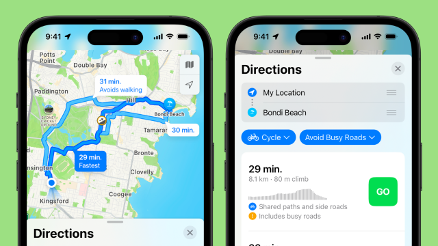
However, on the face of it, having not actually tried them in the real world yet, Apple Maps’ cycling directions seem like they will have been worth the wait. When you search for directions, you’re given several route options which show how much of the route is on a separated path, shared path, or mixed road. You can also see the incline for each route, and whether or not there are stairs (which I still maintain are a weird thing to have on bike paths).
On Google Maps you can see the incline, but the exact nature of the lanes is a bit of a mystery. Also, unlike Google Maps, Apple Maps supposedly doesn’t store any data about you, so it won’t learn how quickly you ride, but instead use the average cycling speed to estimate your ETA. If there’s someone waiting for you, you can share your ETA with them and also give them access to follow you on the map to your destination.
Griggs said it was important to the team to try and differentiate Apple’s cycling directions to those in competitor apps.
“We really tried to design this experience from end to end. One possible approach to creating cycling is just to take driving directions and add a bike icon and call it cycling directions, and we really didn’t do that here,” he said.
“Having shared ETA for cycling is an important part of this feature for us… [As is] having each segment of the route shown on your route preview with what kind of a path you’re going to be on. We really tried to think through, and design very carefully, every single part of this experience as being oriented toward having a great cycling experience for users. That’s just a level of care that I don’t think we really see anywhere else.”
Most helpful, instead of showing petrol stations as places of interest along your bike route, you’re shown public toilets, cafes and bike repair shops. Unfortunately, though, it doesn’t show you circular paths or trails, like the Capital City Trail, with Maps trying to help you commute, rather than help you find interesting rides for fun.
“At this time, we’re more focused on getting you from point A to point B, if you’re commuting or you want to ride to a park or to a friend’s house, something like that. That’s the main focus of the cycling feature right now.”
Unsurprisingly, he would not comment on whether circular paths would be coming in the future.
Although the more detailed, 3D maps are only available in major cities, Griggs insists that the level of detail and accuracy for bike lanes will be consistent across the country.
“One of the great things about building the map from the ground up is that we’ve driven the roads in Australia we’ve collected the information about the road network, and the cycling network along with it. We have this very detailed data across the entire country of Australia. So, you’ll see great detailed cycling routes in the major cities, and you’ll see great detailed cycling routes further out as well,” he said.
Apple Maps got a bad reputation in Australia after it first launched, because back then the map placed the centre of towns in the geographical centre, rather than where the town actually was, which lead to a lot of problems of people getting lost and fire safety apps being inaccurate. Even though Apple Maps has changed a lot since then, that rep has stuck. However, in my experience, walking directions in Australia have been more accurate on Apple Maps for years. Google keeps trying to get me to walk on water, and while I appreciate its faith in me, it is unfounded. These announcements show that Apple has really, properly invested in the new Australian Map, so if it’s been a few years since you’ve given it a try, I wholeheartedly recommend giving it a shot.
There are three main ways to get cycling directions while riding as safely as possible:
- Audio directions alone. You have your bike in your pocket or bag, and then being have the volume turned all the way up so you can hear Siri read out the directions, or you wear bone conduction headphones, like the Shokz OpenRun Pro.
- Get directions on your Apple Watch. The Maps experience has been upgraded on watch to include specific cycling instructions, including when it’s time to get off and walk your bike across the road. As with all directions, the Apple Watch will use haptic feedback to tell you when you turn, and have the instructions in a font akin to the size your grandpa uses on his phone, so you can see it at a glance.
- My preferred way, and I think the safest because you can concentrate a bit better because you’re less worried you’ll miss something, is having a mix of audio directions and mount your phone to your handlebars. I use the Quad Lock system on all my bikes, and it was a total game changer for me. The phone cases are really protective, and they have MagSafe now, so you no longer have to switch between cases if you have a lot of MagSafe accessories. The Maps update will zoom in automatically when you come to an intersection, so you can see more easily where you have to turn, but if you’re still getting the audio directions you won’t have to look down as much.
Cycling directions are available in Apple Maps now.