Google Maps is getting three new features intended to help you coordinate your plans like checking out a landmark without leaving your house or keeping tabs on your friends locations at a festival. Previous features included an area busyness feature or grocery pickup, but these three new features: photorealistic aerial view, cycling routes, and location sharing notifications aim to keep you stay organised, safe, and connected.
Aerial View
“Photorealistic aerial view” will be available at nearly 100 popular landmarks. This view is available for cities like London, New York, Barcelona, San Francisco, and Tokyo, and will give you an overhead look of landmarks in these cities. Amanda Leicht Moore, Director of Product for Google Maps, wrote in a statement that this a step toward “immersive view.”
Immersive view, which was previously announced at Google’s 2022 I/O Conference, combines AI with “ billions of high definition Street View, satellite and aerial imagery.” The view would work like a simulation of the city you want to visit, so you can, for example, check out the interior of a restaurant without actually leaving your house.
Immersive view is not yet available, but aerial view for landmarks has now been rolled out globally on Google Maps on iOS and Android. To find an aerial view of a landmark on Google Maps, Google says to search for the landmark and head to the photos section.
Testing this new feature out, I went to my Google Maps app on my phone, for this example I typed in Tower of Pisa, went to the pictures, and the first thing that popped up was a 30-second video, yes aerial view, of the landmark. So this new feature does not work like Street View where you, the user, are able to move around the area.
Cycling Routes
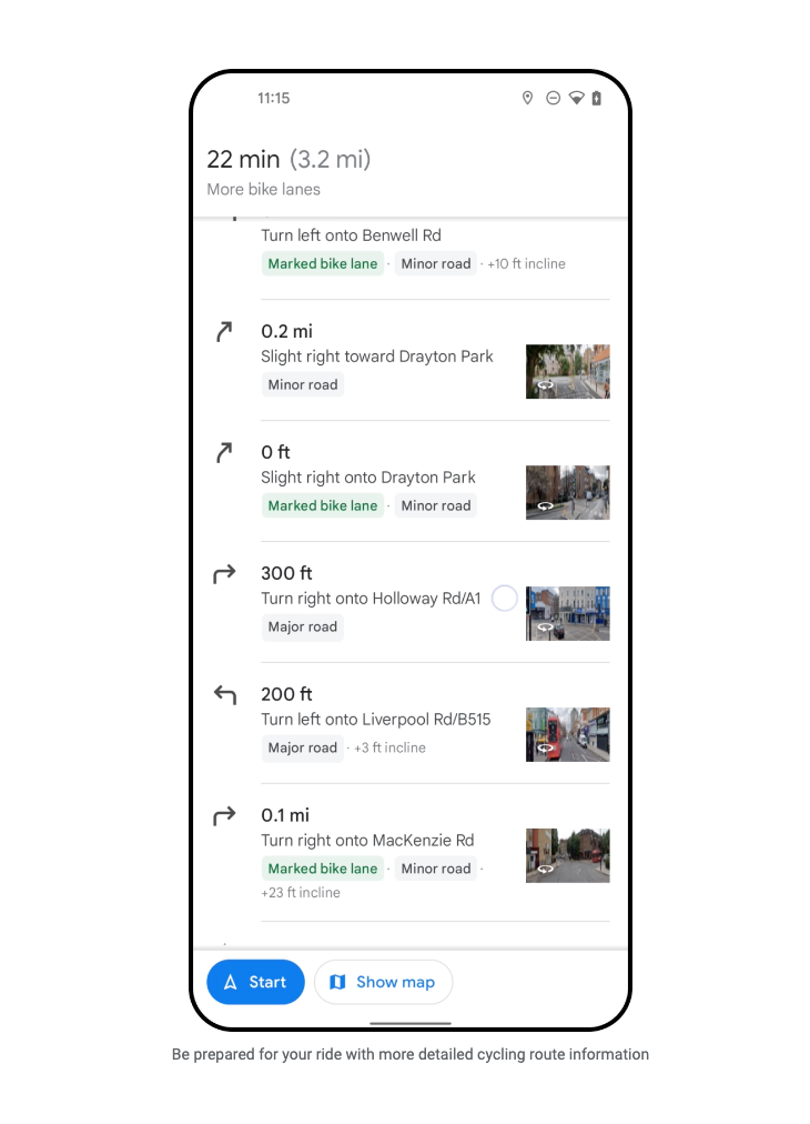
Cycling directions for Google Maps have been available for around 12 years now. This new feature will allow cyclists to compare bike routes and “see even more granular details (when this data is available)” for their journey. (Google has not yet clarified what these granular details are).
You will also be able to see elevation on the route, as well as whether there are steep hills, stairs, or heavy car traffic along your route. The new feature will also give you a highly detailed breakdown of the route so cyclists will know if they are biking on something like a major road or local street. So you no longer have to bike down unknown streets.
This feature will be launching in a few weeks in hundreds of cities.
Location Sharing Notifications
Notifications will now be available for Google Maps, which allows users to be notified when the person that is sharing a location with you has left or arrived at a place. If someone is sharing their location with you, you can set up notifications for a certain address to see when they have arrived.
“We’ve built this feature with privacy at the forefront. Notifications can only be set for someone who has already chosen to share their location with you.” Moore wrote. “ The person who’s shared their location with you will receive multiple reminders to let them know — including both a push notification in the Maps app and an email, along with recurring monthly emails. As always, you’re in control: you choose to stop sharing your location or block someone from setting notifications altogether.”
Location sharing notifications on Google Maps have also started to roll out globally for iOS and Android.