The Pacific Northwest is still reeling from catastrophic flooding unleashed by heavy rains last week. But residents already need to prepare for the next round of calamity.
An atmospheric river is setting up to deliver another double-digit dose of rain, tapping moisture from deep in the tropics and sending it crashing ashore in British Columbia and Washington. The added rainfall could cause some locations to have their wettest November ever recorded — and cause suffering in areas that are still picking up the pieces from last week’s deluge.
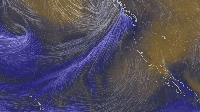
The Atmospheric River Arrives Wednesday
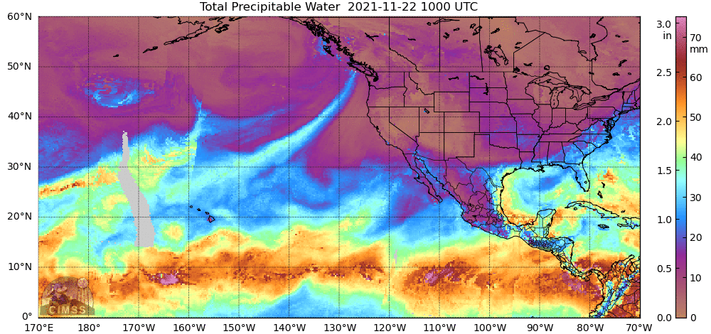
A plume of moisture is lining up from Hawaii and headed toward the Northwest, making this a classic Pineapple Express atmospheric river. As the moisture nears the coast, it will shoot the gap between a high-pressure system to the south and a low-pressure system to the north. Those will act like a Jugs machine, essentially slingshotting the atmospheric river ashore in British Columbia on Wednesday evening.
The first trickle of moisture will hit just in time for Thanksgiving travellers on the U.S. side of the border. That trickle will intensify, though, turning into a torrent on Thursday. The storm could deliver up to 6 inches (15 centimeters) of rainfall for areas along the coast and cause winds to gust up to 40 mph (64 kph). The National Weather Service and its Canadian counterpart, Environment Canada, have both issued various flood and wind warnings for this storm.
This Is the First of Multiple Atmospheric Rivers
The first blast of moisture will be followed by a series of others. After rain tapers off Friday, another system will cruise ashore on Saturday and last through Sunday. Then, rain could pick up again on Monday for what the NWS warns could be “a third, potentially longer-duration system” that keeps things soggy and underwater until Wednesday. When all is said and done, up to 20 inches (51 centimeters) of rain could fall when this event raps up.
A rating created by a group of scientists at the Centre for Western Weather and Water Extremes and other institutions that mimics the Saffir Simpson hurricane scale shows that this series of storms could peak as a Category 4 atmospheric river along the British Columbia coast. The scale factors in intensity and duration, and Category 4 indicates this is a serious storm. Washington, meanwhile, will “only” have to deal with a Category 2 atmospheric river.
Flooding Is a Concern Again
British Columbia was hit particularly hard by last week’s atmospheric river. At one point, every road connecting Vancouver to the rest of Canada was closed as heavy rains unleashed mudslides. This week’s series of storms could bring a whole new wave of debris flows.
Even if the rainfall isn’t as intense as last week’s, there are three factors that could up the flood risk. First, soils are still saturated from last week’s storms. That means more runoff. Adding to the runoff issue are this summer’s wildfires. The monster blazes that ripped through British Columbia destroyed vegetation that holds soil in place and turned slopes into veritable Slip ‘N Slides. That led to monster debris flows last week, and it could do the same with this storm. The soggy, loose soil also means that winds could easily topple trees and standing dead timber, adding yet another hazard.
The third factor is that snowpack has increased in the mountains since the last storm. Yet, as Weather Network meteorologist Tyle Hamilton pointed out in a video, the freezing level is going to rise during the second atmospheric river, meaning that rain will likely fall on snow. That will add yet more water on the ground, and it’s why it’s vital to heed travel warnings, even if it means having to spend an extra day with your in-laws.
The Bigger Picture: La Niña and Climate Change
This is the West’s wet season. Even still, Jacob DeFlitch, a meteorologist at the NWS Seattle office told Capital Weather Gang that “it is fairly extraordinary to have seen this many” atmospheric rivers so early in the season.
A few factors could be contributing the roaring start. The first is La Niña, which formed last month. The natural climate phenomenon is marked by cooler-than-normal waters in the eastern tropical Pacific, which, in turn, impact weather patterns around the world. That includes the Pacific Northwest, where La Niña ups the odds of wetter conditions.
Then there’s climate change. For every 1.8 degrees Fahrenheit (1 degree Celsius) increase, the atmosphere can hold 7% more water. This simple relationship even has a formula to describe it, dubbed the Clausius Clapeyron Equation. (That’s a fun one to bust out at the Thanksgiving dinner table.) That means atmospheric rivers are even more moisture-laden than they used to be. A study published last month in Nature Climate Change, though, finds that industrial pollution has acted as a damper on atmospheric rivers and essentially led to a stalemate from 1920 to 2005.
That balance is beginning to shift, though, and will continue to in the coming decades as climate change exerts greater control and leads to more intense atmospheric rivers. With more intense wildfire seasons also on tap thanks to rising temperatures, that means that the heavier rainfall will have more slopes to dislodge into unstoppable disasters.