The U.S. is the meat in a bomb cyclone sandwich. (Ewww.) The West Coast was blasted by a monster storm on Monday and now the East Coast is being struck by a similarly fierce one.
A nor’easter roared into the New York metro area on Monday night, sending bands of rain ashore across the region. The storm will continue to climb into New England where Cape Cod and other areas could see hurricane-force winds in what is basically a carbon copy of what just happened on the West Coast.
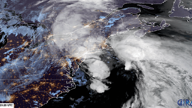
The Nor’easter Is Another Bomb Cyclone
A bomb cyclone is a catch-all term for storms that intensify unusually rapidly. The nor’easter is the latest to join the fun. As of Tuesday morning, it fulfilled the criteria to “bomb out.”
This is largely a bit of meteorological wonkery. But we love wonkery, don’t we, folks? The definition for a bomb cyclone is one that sees pressure drop at least 24 millibars in 24 hours. The nor’easter surpassed this milestone, dropping 994 millibars as of Tuesday morning.
Lower pressure generally equates with more intense weather impacts on the ground. The nor’easter isn’t quite as intense as the bomb cyclone that just raked the West Coast, but that doesn’t make it any less of a problem for people in its path.
Heavy Rain Is the Big Problem — But Wind Could Be a Factor
Up to 16 centimetres of rain could fall across the Northeast region over the next 24 hours. The heaviest totals will pile up to the west and north of New York City, but a wide swath from upstate New York to the Massachusetts coast will see at least a couple inches of precipitation.
An area from Pennsylvania to Massachusetts is under flood warnings and watches. That includes a good chunk of flash flood warnings in New Jersey, indicating that extreme rainfall could fall over a short period in those locations. Here is your ever-present reminder to not drive on flood roadways or enter floodwaters on foot for fun.
Strong winds could also wreak havoc along the coast and cause power outages. The most intense winds will hit Massachusetts. Gusts could crank up to 121 kph along the Cape, a speed equivalent to a Category 1 hurricane. The National Weather Service has, perhaps not surprisingly, issued a high wind warning.
“Damaging winds will blow down trees and power lines,” the agency wrote in that warning. “Widespread power outages are expected.”
The Nor’easter is No Ida (Whew)
The “good” news, in as much as there can be good news with an intense storm, is that it will be nowhere near Ida levels of intensity. The then-tropical depression brought catastrophic rates of rain to the New York metro area, killing dozens and damaging infrastructure throughout the region.
Ida is a tall stick to measure against, though. Just because the nor’easter isn’t on that level doesn’t mean it’s not a threat. If you’re in the regions under any of the watches and warnings issued by NWS or in a state where a state of emergency has been declared, pay attention.
These types of extreme rainfall events have become increasingly common as the planet heats up. A warmer atmosphere can hold more water, meaning that more of what goes up must also come down. The Northeast has seen the biggest uptick in extreme rainfall in the U.S., with a 71% increase in the amount of rain falling in the top 1% of all rainstorms since 1958. Like Ida, the nor’easter fits a pattern
Weirdness in the Arctic Is Driving the Wild Weather
Getting two intense storms on two coasts almost simultaneously is a pretty odd occurrence. In fact, the nor’easter may be getting a little juice from the West Coast, with a snap of energy rippling through the jet stream across the country. Add in powerful winds that are expected on Tuesday across parts of the Plains — where a red flag warning is in place — and tornadoes that ripped across Illinois and Missouri on Monday, and things seem downright freaky. (The winds in the Plains on Tuesday could unleash severe weather and tornadoes on Tuesday night or Wednesday morning, adding to the weather woes.)
The cursed weather isn’t due to Halloween being less than a week away, though. While these systems may be influencing each other, weather in the Arctic may also be playing a role. There, two systems are parked in ways that are forcing the jet stream to do a contortionist act. That fast-flowing river of air acts as a dividing line in the atmosphere between the polar regions and the tropics. But weather systems — whether they be stormy lows or sunny highs — can cause the jet stream to ripple. And right now, it’s rippling in a major way.
High pressure over Hudson Bay and low pressure off Greenland have created what’s known as a trough in the atmosphere, forcing the jet stream to take a major dip in the Midwest and then a wild swing north in the Northeast. That creates a race track for storms to follow, wreaking havoc as they go. There’s some evidence changing sea ice conditions in the Arctic could drive extreme weather outbreaks to the south, but it’s an active area of research.