Here’s an ominous sign of the times: Alongside other more mundane data like traffic, satellite, transit maps, and tree cover, fire will now be one of the top layers in Google Maps
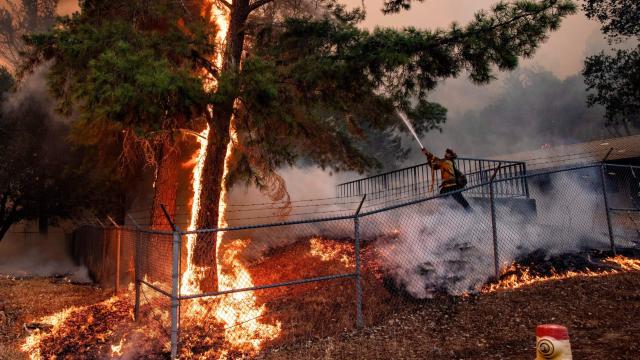
Massive wildfires that ravage large swathes of the U.S. — particularly California, which currently has 17 active wildfires and has seen a shocking 5.1 million hectares burn since 2012 — are now so common that the term “unprecedented” no longer applies. That’s also true of many other regions afflicted by climate change and encroaching development, such as Australia, where the 2019-20 fire season killed dozens and emitted as much smoke as a major volcanic eruption.
Wildfires can spread rapidly, and the climate change-fuelled ones sweeping regions like California can be even worse, with fires consuming new territory at rates clocked at up to 24 km/h. At the same time, more people have moved to what’s known as the wildland-urban interface, putting millions of people in harm’s way. The combinations of these factors can turn deadly.
Confusion and lack of situational awareness are major contributing factors to casualties. In the 2018 Camp Fire, which destroyed the town of Paradise, California, and killed at least 86 people, authorities were slower to notify many residents than the encroaching blaze was to reach them. Many in the area received little advance warning the fire was about to hit the town at all. Accessible fire maps could be the difference between escaping a wildfire or trying to leave too late.
In a blog post, Google Earth & Images Director Rebecca Moore wrote that the system will use satellite data to “help people in the U.S. easily understand the approximate size and location of a fire.” The new layer, which expands on prior Google initiatives such as a “crisis response” website, will also connect users to information on emergency services and evacuation routes.
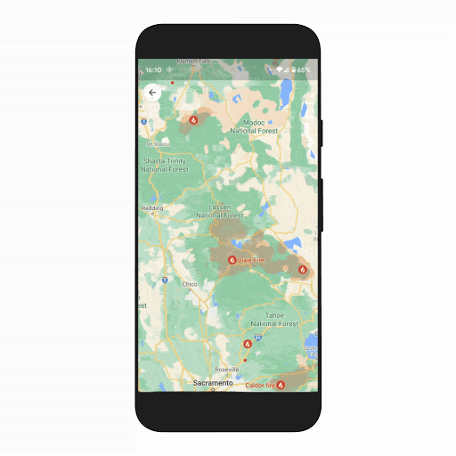
“With the wildfire layer, you can get up-to-date details about multiple fires at once, allowing you to make quick, informed decisions during times of emergency,” Moore wrote. “Just tap on a fire to see available links to resources from local governments, such as emergency websites, phone numbers for help and information, and evacuation details. When available, you can also see important details about the fire, such as its containment, how many acres have burned, and when all this information was last reported.”
According to Ars Technica, Google says the data will be updated on an hourly basis and. The new fire layer will roll out to Android this week, with iOS and desktop users getting it in October.
Google is simultaneously expanding the Tree Canopy layer it launched last year, which Moore wrote uses “aerial imagery and advanced AI capabilities to identify places in a city that are at the greatest risk of experiencing rapidly rising temperatures.” That helps urban planners and city officials identify heat islands, areas that are significantly hotter than neighbouring ones thanks to lots of concrete and asphalt and not much greenery.
The tool will now cover 100 cities worldwide, up from 15. Moore also wrote that Google is launching an Address Maker app, which helps governments and NGOs assign functioning addresses to buildings and identify roads by name in under-served areas.