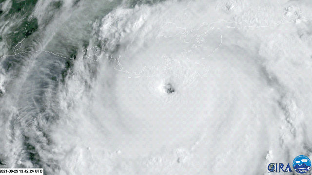
The worst has come to bear with Hurricane Ida. The storm has rapidly intensified into a Category 4 beast and landfall in southeast Louisiana is imminent.
Ida strengthened over the course of Saturday and has 240 km/h winds as it approaches the coast. The U.S. National Hurricane Centre is already receiving reports of sustained winds of 165 km/h — the equivalent of Category 2 winds — hitting Louisiana, and things will deteriorate from here throughout the day as Ida comes ashore with powerful winds, crushing storm surge, and torrential rain. This will be the third major hurricane to strike Louisiana in a year, following last year’s Laura and Delta.
Ida also comes as the state is in the midst of its worst covid-19 wave since the pandemic began along with a host of other background conditions that will make the recovery from Ida that much harder. In an era of what climate justice essayist calls “crisis conglomeration,” this is it.
Ida’s Winds Are in Dangerous Company…
The winds are what are rightfully grabbing everyone’s attention, but they’re far from the only danger. Ida is poised to be the fourth-strongest storm by windspeed to ever make landfall in the U.S., according to hurricane expert Philip Klotzbach. That’s small comfort, though; the storms in Ida’s company are some of the worst to ever strike the country. The two most recent are Hurricane Andrew and Michael, multibillion-dollar disasters that wiped coastal communities off the map in Florida in 1992 and 2019 respectively.
… But Water Will Be the Biggest Concern With Ida
Not to dismiss the wind, but the greatest damage we’re likely to see from Ida will come from the water, which traditionally has been the greatest source of hurricane destruction. Specifically, it’s about how much of it Ida pushes ashore and how much the storm drops from the sky.
Storm surge could reach 5 metres along large parts of the coastline from the petrochemical hub of Port Fourchon (which is also poised to take a direct hit from Ida’s eyewall and the strongest winds) to the mouth of the Mississippi River. Water will come ripping through the tidal marshes and bayous that look like Swiss cheese from above, threatening the communities interspersed throughout the region.
Then there’s the rain. Ida will bring curtains of precipitation across the region, far from where its eye makes landfall. The storm will slow down as it moves inland, which means Ida’s bands of rain will repeatedly wash over the region. Up to 0.6 metres of rain could fall, unleashing catastrophic flooding far inland from the storm.
New Orleans sits outside the path of Ida’s eyewall, which is a small bit of only moderately terrible news. But it is on the northeast side of the storm, which is generally the side of maximum impact due to the way hurricanes rotate. That means it could still see serious impacts (as could parts of the Mississippi Gulf coast. Parts of New Orleans outside the city’s rebuilt levees could see more than 2 metres of surge and some pockets where waters could rise more than 3 metres as Ida pushes water ashore. The surge will test the levee system that was reconstructed after Katrina, but it’s designed to withstand this type of surge. This storm will be a major test.