Well, apparently this is Hot Dome Summer.
The U.S. has been besieged by yet another heat dome leading to stifling heat across not just the West but much of the eastern half of the country, too. While not as fierce as the Pacific Northwest heat wave in late June, the extent and timing of this heat are both notable. And by notable, I mean very concerning and dangerous.
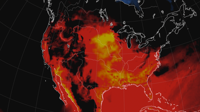
All told, 17 states are under some form of heat watch or warning from the National Weather Service. Smoke from wildfires spreading across North America will only compound the heat woes, and in a disappointingly familiar fashion, the heat could lead to more blazes and even worse drought.
The Heat Runs From Coast to Coast
This summer of heat domes has seen extreme highs isolated (relatively speaking) to regions of the U.S. First, it was California. Then the Pacific Northwest. Then California, Nevada, and Utah. Then the Northern Rockies.
All large areas to be sure, but this blast of heat is even more widespread. The 17 states under heat warnings run from Montana — including counties right up against the Canadian border — to Georgia. Triple-digit heat is likely for upwards of 30 million people at some point this week. In addition, humidity will conspire to make temperatures even more stifling in parts of the country such as the Gulf Coast and Midwest.
Parts of Oklahoma and Arkansas are under an excessive heat warning, while Iowa and Minnesota are under an excessive heat watch — an extremely ominous type of alert NWS issues when the heat index rises above 105 degrees Fahrenheit (40.6 degrees Celsius) — for anywhere west of the Blue Ridge Mountains (very specific, I know). A warning is issued when hot conditions are happening or imminent while a watch means those conditions are likely in the next 24 to 48 hours. Either way, things are going to be pretty uncomfortable.
In the South, the heat index is expected crest at 113 degrees Fahrenheit (45 degrees Celsius) on Tuesday while the Midwest will get the worst of it on Wednesday when the index rises as high as 109 degrees Fahrenheit (42.8 degrees Celsius).
“Extreme heat and humidity will significantly increase the potential for heat related illnesses, particularly for those working or participating in outdoor activities,” NWS wrote in the watch for Iowa and Minnesota. “Low temperatures in the low to mid 70s Tuesday night will allow for little relief from the heat overnight, with the warmest conditions expected Wednesday afternoon.”
Wildfires and Drought Are Going to Get Worse
The heat is a key ingredient to the other weather miseries we’re dealing with: drought, wildfires, and terrible air quality. The West and parts of the Upper Midwest are already facing a formidable drought, and the heat will sap more moisture out of the soil and vegetation. That will worsen drought and increase the odds of existing wildfires spreading and new ones exploding.
That will, in turn, worsen air quality in the region and in points as far away as Maine. As of Tuesday morning, Bangor, Maine, had the same hazardous air quality as Butte, Montana. Butte is in the shadow of multiple large wildfires while Bangor is a thousand-plus miles away from the nearest big blazes (those would be in western Ontario, for the record). But the smoke has travelled and descended across the northern part of the U.S. and parts of Canada as well, just as it did last week.
Air quality alerts are also up in Texas and parts of the South. Those have less to do with wildfire smoke and more to do with the fact that intense heat can create ground-level ozone, a pollutant that’s produced through chemical reactions that get sped up by heat.
A Heat Dome Is Behind This — and Other — Extreme Events
The term “heat dome” has become all too familiar lately. It essentially is an area of high pressure that parks over a region, leading to hot conditions that actually strengthen the high pressure and make things worse.
The U.S. has seen a series of them on a near-weekly basis this summer. These areas of high pressure can also shunt the jet stream into wild dips and curves, bringing erratic weather to other locations. We’ve also seen that on a near-weekly basis around the world, with intense heat in Siberia and major floods in China, Europe, and India.
Some research indicates climate change is amplifying this type of pattern because the Arctic is warming faster than the rest of the world. That lowers the overall temperature gradient between it and the tropics, a gradient that normally keeps the jet stream in a less wobbly straight. It’s an area of active research, though.
Climate Changes Mean More Heat Like This Is Coming
What is clear, however, is that extreme heat is becoming more common and intense, and the trend will get even worse in the coming decades. Climate scientists published a study this week in Nature Climate Change, titled, “Increasing probability of record-shattering climate extremes,” which is scientistspeak for “world leaders have fucked around, now we’re about to find out.”
The paper shows that the chances of extreme heat — or what the paper helpfully defines as “record-shattering extremes” — lasting at least a week will become dramatically more common if the world continues to burn fossil fuels with abandon. The studies shows these types of events could become “two to seven times more probable in 2021–2050 and three to 21 times more probable in 2051–2080, compared to the last three decades.” In other words, the Hot Dome Summer is basically just a warmup.