Record-setting Hurricane Eta has cleared Central America after leaving a trail of destruction. The cyclone is a much-weakened tropical depression, but it’s set to strengthen in the coming days and take a wending, circuitous path through the Caribbean and Gulf of Mexico. It could make landfall in the U.S. early next week.
Before we get there, though, we need to talk about the very serious damage Eta did to Central America. At least 50 are dead across Honduras, Nicaragua, and Guatemala, which were lashed by what was an incredibly powerful storm at its peak. As a hurricane, Eta delivered pummelling winds where it roared ashore as the strongest storm to make landfall in Nicaragua in more than two decades. The storm also dumped copious rains across the entire region, unleashing deadly landslides and flooding. The National Hurricane Centre said in its Friday morning forecast that a few more inches are possible as Eta moves away from Central America; rainfall totals could top out at 100 cm by the time the storm is finished with the region. The Red Cross estimates 400,000 people have been directly impacted by Eta in Honduras alone.
“This is probably one of the biggest threats the country has faced since the passage of Hurricane Mitch in 1998,” Felipe del Cid, the head of operations for the Red Cross Americas region, said in a statement.
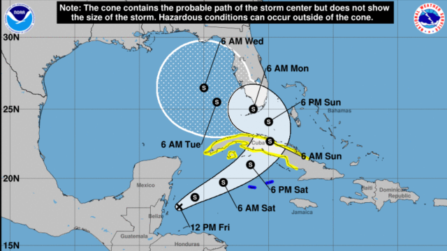
Eta finally moved offshore late on Thursday night as a doughy mass of clouds and rain. Unfortunately, conditions are favourable for it to strengthen from a tropical depression back into a tropical storm as it traverses the western Caribbean toward Cuba. Large parts of the country are under a tropical storm watch while the Cayman Islands to the southwest are under a tropical storm warning.
While winds won’t be anywhere near Eta’s peak of 241 kph, the storm could still pack a punch as a high-end tropical storm at landfall in Cuba. But the rainfall is what’s more worrisome. NHC forecasts show Eta is expected to dump 255 to 510 millimetres over Cuba and the Cayman Islands, and some locations could max out at 760 millimetres of rainfall. That could cause landslides and flooding similar to what Central America is still reeling from.
Then, just because 2020 hasn’t been exhausting enough, Eta may make a third landfall somewhere in Florida. There’s a lot of uncertainty about where or even if the storm makes landfall this far out. South Florida is squarely in the NHC cone, though, with the Florida Keys and Everglades at the centre and Miami not out of the woods by any means. The forecast calls for 125 to 255 millimetres of rain, though some locations could get a lot more. Since the start of September, those locations have been much wetter than average, and over the last two weeks of October, they’ve had some of the highest rainfall totals ever recorded over that period. That increases the odds of runoff and flooding — and also fits in line with a climate trending toward more downpours driven by overheated atmosphere.
In a year where multiple hurricanes have made landfall, a pandemic is raging, and Republicans are making up claims about voter fraud to draw out the U.S. national nightmare despite the fact that we all know Joe Biden will almost certainly win the presidential election, I am frankly not here for this possibility. In the spirit of problem-solving, may I humbly suggest we dispatch some Philly voters to swat Eta away and save our nation twice in the span of a week.