Fire, heat, storm surge, and wind have all made appearances on our record-setting disaster bingo card in the past month. Now, record rain and flooding is about to show up.
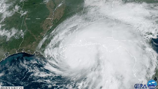
Hurricane Sally is angling toward the Mississippi and Alabama coastline for a Wednesday landfall. While many folks’ eyes will be on what category the storm is at landfall, the real concern with Sally isn’t wind (though folks in region should take note). It’s the “historic” and “life-threatening” flooding that the National Hurricane Centre is calling for.
As of Tuesday afternoon, Sally is Category 1 hurricane with winds of 85 mph (137 kph). Not anything to sneeze at, but the storm is nowhere close to the monster that was Hurricane Laura a little less than three weeks ago, which made landfall with winds of 150 mph (241 kph) on the Louisiana-Texas border. Ditto for the storm surge, which could top seven feet (2.1 meters) on the Alabama-Florida border but won’t approach the chaos of Laura.
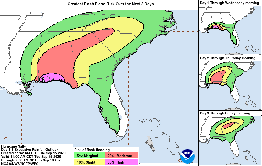
What Sally lacks in punch when it comes from winds and surge, though, it will make up for with rain. Forecasts are currently calling for widespread rainfall totals of 10 to 20 inches (25 to 50 centimeters) and isolated areas where rainfall could approach or even exceed 30 inches (75 centimeters). Here’s the full NHC description of what to expect as the storm moves closer to the shore and makes landfall sometime on Wednesday morning:
“Historic flooding is likely with extreme life-threatening flash flooding likely through Wednesday. In addition, this rainfall will lead to widespread moderate to major flooding on area rivers.”
Flooding is also expected further inland as far north as the Carolinas as the storm unleashes a torrent of heavy rain even as it weakens. Mississippi and Alabama could set records for all-time rainfall totals from a tropical cyclone if Sally overperforms the forecast by even just a few inches. That would break longstanding records.
There are a few reasons why widespread, catastrophic rainfall is likely. The first is the pace the storm is moving at: Sally is taking a leisurely path over the Gulf of Mexico at a rate of 2 mph (4 kph). Your grandmother could probably beat this storm in a foot race right now. A trough of low pressure over the central U.S. is essentially pressing down on Sally, causing the storm’s slow northward progress, as is a general slackening of winds that normally steer storms through the Gulf of Mexico.
While all this might make your grandma feel like she still has it, Sally’s glacial pace means it will take an agonizing amount of time to move across the Gulf Coast, allowing the storm to dump copious amounts of rain. A similar situation happened with Hurricane Harvey in 2017, when the storm raked Houston and the surrounding area for days and dropped as much as 60 inches (152 centimeters) of rain. Sally will spend a little less time meandering than Harvey, but the results could still be destructive for any community caught in the storm’s path.
There are also a host of ways climate change could be influencing Sally. Research published in 2018 shows that tropical cyclones are slowing down as they make landfall owing to the fact that the poles are warming faster than the mid-latitudes. A bigger temperature difference causes the winds that separate the two regions to blow faster, and the slowdown could be one reason for stalling hurricanes like what we’re seeing with Sally.
The warmer world also allows cyclones and everyday rainstorms to hoover up and hold more water in the atmosphere. Research published in the wake of Harvey found that climate change increased the odds of its record-setting rainfall. Heavy downpours have increased in every part of the country. Along the Gulf Coast, they rose 27% from 1958 to 2016, and the future is projected to get even more intense. Research published earlier this year shows that 1-in-100-year rainfall events in preindustrial times are now happening every 20 years on average. If the world manages to cap warming to Paris Agreement levels, those events would still happen once every five years on average.
There’s also plenty of issues with the built environment and how it’s been designed to handle storm runoff — or, in many locations with lots of impervious surfaces, designed not to handle it. But the state of things on the ground will only compound the dangerous situation shaping up in the atmosphere.