Gizmodo began the week by noting things looked bad in the Atlantic. And because the Atlantic is on a bender, we’re ending the week the same way.
The storms are mostly new. While there are currently fewer named ones spinning in the basin, the ones that are there are major trouble. We’ve also run out of traditional storm names, which means we’re headed to Greek alphabet as soon as the weekend.
The current record holder for most active hurricane season is 2005, which had 28 named storms. It was the first and (for now) only time the U.S. National Hurricane Centre dipped into the Greek alphabet, with the season ending on Tropical Storm Zeta. The way things are shaping up, this year is on pace to break the record for most named storms to form in the basin. Even if this spate of activity doesn’t boost the season over the edge, we still have two and a half months left in hurricane season.
Since there’s so much going, Gizmodo wanted to recap the good, the bad, and the ugly of the Atlantic in its current state. Spoiler: It’s mostly bad and ugly.
Just Chilling
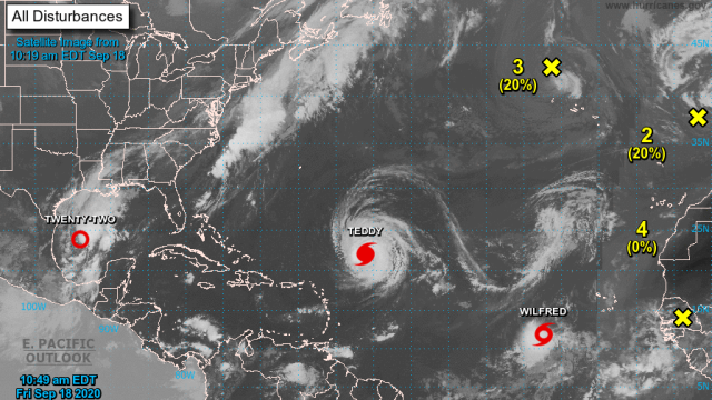
There are three storms to watch across the western Atlantic. The odds of them imminently turning into a raging hurricane, let alone a tropical storm, are currently low. So I guess this is the “good” part of the Atlantic situation right now.
But they’re still an issue since the one closest to Europe is causing gale-force winds and rain to whip Portugal. Gale-force winds are on par with tropical storms, so even though the storm isn’t named, it’s still pesky!
The one in the North Atlantic is also an oddity we should talk about briefly. It’s the remnants of Hurricane Paulette, which struck Bermuda earlier this week and then hooked back toward Europe. Paulette has since become a post-tropical storm, but the National Hurricane Centre warns it could “redevelop tropical characteristics late this weekend or early next week” as it buzzes the Azores. Because why not.
Our Last Named Storm on the List
For its 11 a.m. ET update, the U.S. National Hurricane Centre (NHC) officially exhausted the list of tropical cyclone names for the Atlantic. Tropical Storm Wilfred formed in the southern part of the Atlantic. It’s expected to meander along and pose no threat to land for the foreseeable future.
Pretty ho-hum stuff at this point, but it’s the last named storm of the season, so Gizmodo decided to give it its due. Cheers, Wilfred?
Time to Brush Up on Greek and Prepare for Rain
While it doesn’t have a name (yet), Tropical Depression 22 is a storm to watch. The depression in the Gulf of Mexico should become a tropical storm as soon as today and almost certainly by Saturday morning. Your humble correspondent went to a school that didn’t have sororities or fraternities, so the Greek alphabet is, uh, Greek to me. But Wikipedia tells us Tropical Depression 22 is slated to become Tropical Storm Alpha.
It could strengthen to Hurricane Alpha as it nears the Texas coast. While it won’t be another Harvey, per se, the track is eerily reminiscent of the most prolific rainstorm in Texas history. Alpha-to-be is slated to crawl up the coastline early next week, with much of the Texas Gulf Coast in the cone of probability. The slow movement is similar to what happened with Harvey as well as this week’s Hurricane Sally, which moved inland at the agonizingly glacial pace of 3.2 km/h. There’s still some uncertainty about what this storm could do and what landfall could look like, but anyone along the Texas coast should pay attention to the forecast as it develops.
Canadacane?
Hurricane Teddy is a ferocious monster of a storm that’s thankfully nowhere near land. Its winds are whipping to 209 km/h, making it a major Category 4 hurricane.
While it’s nowhere near land now, that will change as it moves north. Bermuda sits on the edge of the cone and could feel the direct impacts of Teddy by Sunday. So definitely a storm to watch there, and the NHC may well issue hurricane watches and warnings by this evening.
But Teddy doesn’t plan to stop there. Rather than hooking out to sea, it’s expected to keep trucking northward and make landfall in Nova Scotia. By then, it could be post-tropical meaning it has a cold core instead of a warm one, plus a few other characteristics that matter to weather nerds. But for those in Atlantic Canada, the results on the ground are what matters. Teddy could bring winds of around 105 km/h and bands of rain to lash the region.
Nova Scotia is no stranger to hurricanes, post-tropical or otherwise. In fact, just last year it was hit by Hurricane Dorian after the storm left a trail of destruction in Bermuda. But it still sucks!
BONUS! Medicane
OK, so it’s not technically an Atlantic storm, but the Mediterranean feeds into the Atlantic and also it’s called a medicane so not writing about it feels like a dereliction of duty. Look at this weirdo:
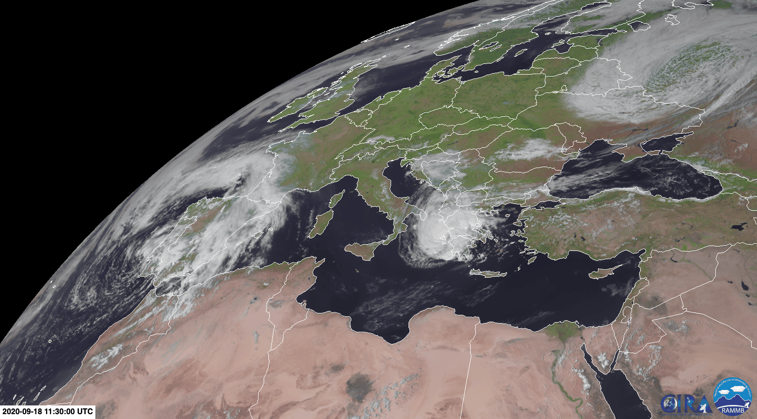
My guy here is known as Storm Ianos. It made landfall in Greece on Friday and is proceeding to make an absolute mess of things. Up to 20 inches (50 centimeters) of rain have fallen and winds are racing up to 125 km/h, putting it on par with a Category 1 hurricane. In the Mediterranean.
Everything is extremely normal and fine.