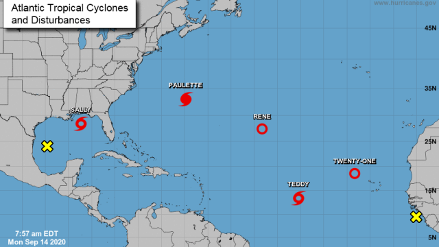
I do not like this map one bit. The Atlantic hurricane season from hell is kicking into overdrive with five tropical cyclones dotting the map, two more that could form in the next week, and one particularly worrisome storm heading for the Gulf Coast.
We’re in the heart of hurricane season, but this level of activity is nearly unprecedented. The only time on record that there have been more than five tropical cyclones (the catch-all name for tropical depressions, storms, and hurricanes) in the basin simultaneously was in September 1971, when six storms were swirling.
While those storms included the names running from “E” to “I,” this year’s series of storms is already up to “P” through “T.” Storms in the Atlantic are named in alphabetical order. The fact that we’re at “T” for this flurry of activity shows how off-the-charts this hurricane season has been, with a steady barrage of storms forming all over the basin due to a combination of factors, including calm upper winds and hotter than normal oceans.
We can lump the five storms and two areas to watch into four categories: weird but not a threat (for now), wannabes, damagers, and serious concern. So rather than dissect each storm, let’s walk through each of those categories below.
Weird but not a threat (for now)
Thankfully, most of these storms fall in that category.
Tropical Depression Rene and Tropical Storm Teddy look destined to avoid land. Rene was a tropical storm but has just been puttering aimlessly and is expected to stay pretty weak and rudderless. Teddy, meanwhile, will ramp up and is expected to become a major hurricane by the end of the week. It will still be far out to sea, though, and the National Hurricane Centre (NHC) is forecasting that it’ll start to curve northward away from the Caribbean. The track it’s on through the next seven days shows it poses no threat to land, and it should recurve out to sea — but it’s 2020, so let’s keep an eye on it.
Tropical Depression 21 is still on the other side of the Atlantic, which means it’s tough to get too worked up about it at this time. Frankly, we have bigger things to worry about.
Wannabes
The NHC is currently watching two areas of vigorous thunderstorms, usually a precursor to tropical cyclones. The one in the Gulf of Mexico is pretty marginal, with the agency giving it just a 10% chance of becoming a tropical cyclone. So let’s feel free to point and laugh at it, but not too loud in case it decides to get its act together.
The other area to watch is a tropical wave coming off Africa. These puffs of low pressure that push off from the continent are remnants of the West African monsoon season. They can also be the source material for hurricanes, particularly those that form in an area of the Atlantic known as the main development region (I’m sure you can guess why). The NHC currently gives this wave a 40% chance of becoming a cyclone by the end of the work week.
Damagers
Hurricane Paulette is currently the strongest of all the storms, with winds of 153 km/h. It made landfall in Bermuda in the early hours of Monday morning. Paulette is still over the island, though thankfully moving away at a fairly rapid clip. Nevertheless, the NHC warned that “dangerous storm surge is expected to produce significant coastal flooding on Bermuda in areas of onshore winds. Near the coast, the surge will be accompanied by large and destructive waves into this afternoon.” Up to 6 inches of rain could fall as well.
After the storm passes over Bermuda, it’s expected to steer north and east away from the U.S.
Serious Concern
Alas, there’s another storm for the U.S. to worry about. The Gulf Coast is about to face its second landfall in less than three weeks. Tropical Storm Sally is approaching Louisiana from the east and is expected to strengthen into a hurricane on Monday before making landfall on Tuesday.
The storm is no joke; hurricane-force winds could reach the shores of Mississippi and Louisiana as soon as Monday evening. Sally could bring up to 11 feet of storm surge ashore near the mouth of the Mississippi River and other parts of the Louisiana and Mississippi coastline. A large area could see a foot or more of rainfall, including locations far from the coast. Flash floods are a major concern, particularly in urban areas that include New Orleans. The city also faces possible storm surge, which raises the risk of compound flooding from water pushing inland from the ocean and heavy rain trying to drain out to sea.
The combination of the two will test the city’s flood defence systems, including levees rebuilt after Hurricane Katrina 15 years ago and a series of pumps designed to ferry water out of the city. As a reminder, this is what happened last year when the city saw a foot of rain.
The impacts will extend well beyond the Big Easy, though, to an area that’s already dealing with wetter than normal soil. (Here’s what happened in 2016 to interior parts of Louisiana when a no-name rainstorm that Sally has similar rainfall potential to hit inland.) It’s not good, and regardless of what category Sally is when it makes landfall, residents in its path should be prepared for a soaking.
All this is bad news for a region that was hit by Hurricane Laura, a catastrophic Category 4 storm that pummelled the Texas-Louisiana border. While that area will likely be spared from Sally, the back-to-back disasters will tax already strained emergency management infrastructure and personnel who are dealing with the aftermath of that storm and pandemic.