A surprisingly large pit structure has been discovered around Durrington Walls Henge, which is less than 3 km away from Stonehenge. Dated at 4,500 years old, it’s the biggest prehistoric structure ever found in Britain.
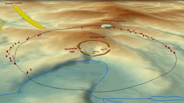
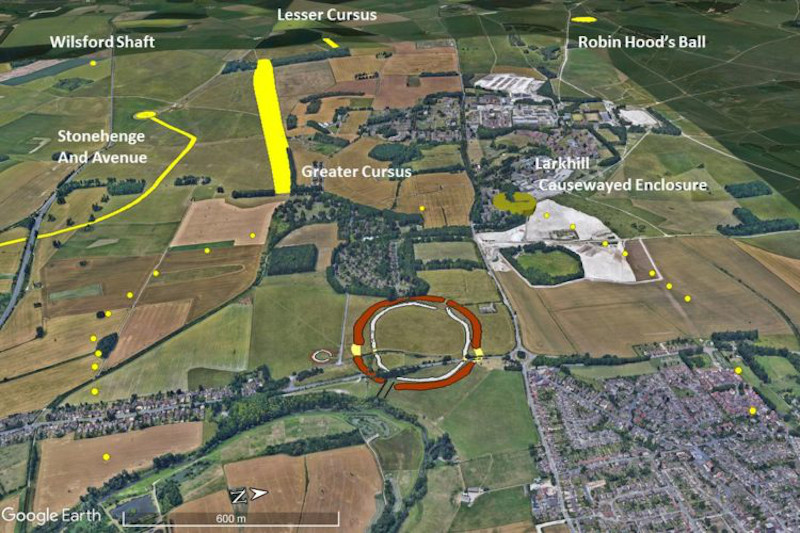
Located on Salisbury Plain in the United Kingdom, the circular structure consists of at least 20 carefully positioned pits. Now buried, these pits were huge, at more than 5.03 m deep and 10 to 20 metres wide. Together, these pits formed a circle measuring more than 1.3 km in diameter. At the centre of this circle is Durrington Walls Henge, one of Britain’s largest henge monuments. The pits are, on average, around 864 metres from the centre point. Details of this incredible discovery were published today in the scientific journal Internet Archaeology.
“The numbers and the layout of these features is unique as far as I am aware, and they constitute the largest prehistoric structure in Britain,” Vincent Gaffney, a co-author of the new study and an archaeologist at the University of Bradford, wrote in an email to Gizmodo. The entire structure encloses an area measuring 300 hectares, he said.
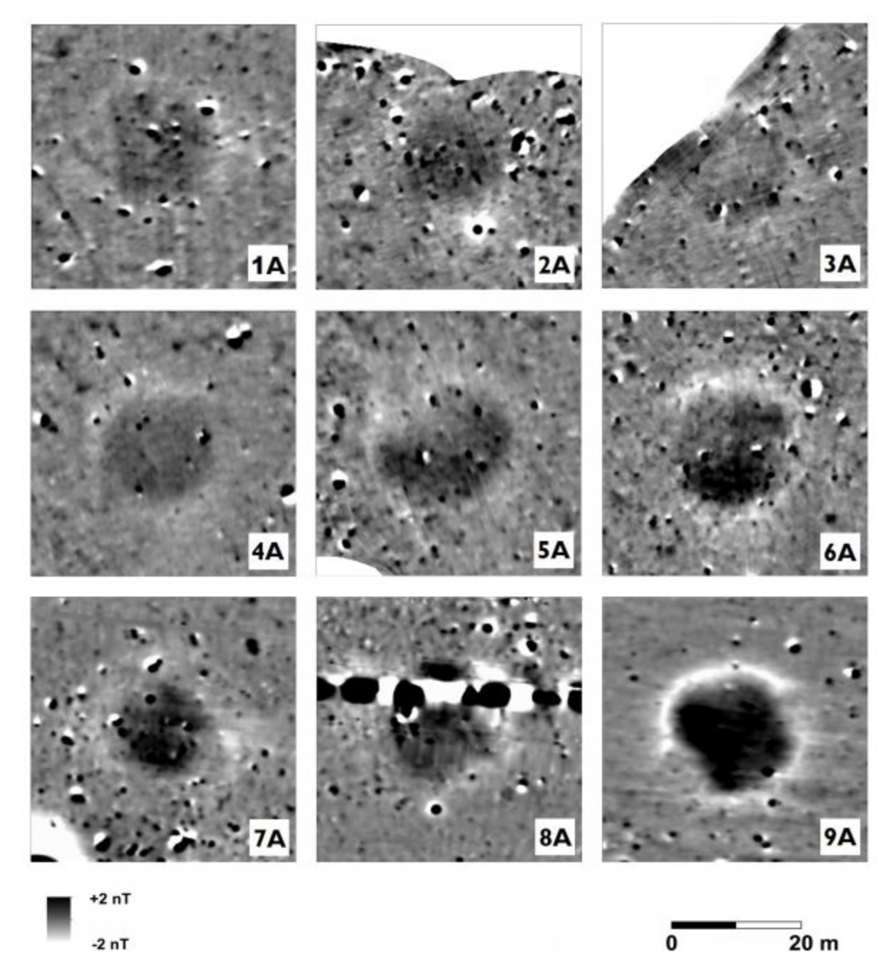
The pits were previously thought to be a series of dew ponds or sink holes, which is why they were ignored for so long. Several remote sensing tools were used to detect and characterise these “massive geophysical anomalies,” as they’re described in the paper, including ground-penetrating radar and magnetometry. These surveys were undertaken by the Stonehenge Hidden Landscapes Project (SHLP), with help from the Ludwig Boltzmann Institute for Archaeological Prospection and Virtual Archaeology, St. Andrews University, and other institutions.
“This discovery was made possible by the increased use of remote sensing surveys over very large areas,” said Gaffney. “We can see things invisible to past archaeologists, and this is allowing us to join up the dots in a way we could never have previously imagined.”
Indeed, remote sensing tools are revolutionising archaeology, allowing scientists to investigate buried or hidden spaces without having to lift a shovel.
[referenced url=”https://gizmodo.com.au/2020/06/ground-penetrating-radar-reveals-entire-ancient-roman-city/” thumb=”https://gizmodo.com.au/wp-content/uploads/2020/06/09/zqzvq1l5jkrkauniolb6-300×169.gif” title=”Ground-Penetrating Radar Reveals Entire Ancient Roman City” excerpt=”For the first time ever, archaeologists have used ground-penetrating radar to map an entire city while it’s still beneath the ground.”]
The site was not formally excavated, but a series of core samples were extracted for radiocarbon dating. This structure was built some 4,500 years ago during Britain’s Neolithic period, when farming was spreading in the region. The core samples also yielded bits of flint and bone.
Gaffney said Neolithic people would have used “antler picks, scapula shovels, stone tools, sweat, and tears” to excavate the pits. Given the tremendous size of the pits, it’s fair to say a tremendous amount of social coordination was also required. These people “moved a vast amount of earth, but the same society also built Stonehenge, so we know that they were capable of immense community efforts,” Gaffney told Gizmodo. As to what this structure looked like at the time, “we have no idea,” he said, adding that “without excavation we cannot tell.” It’s possible, for example, that the pits were covered.
In terms of its purpose, the structure may have designated a boundary to a sacred space, either guiding or warning people that they were approaching the Durrington ritual site, according to the researchers. The data also suggests this structure was maintained into the Middle Bronze Age (1400 to 900 BCE), which, if true, “would have significant implications for our understanding of the history and development of monumental structures across the Stonehenge landscape.,” the authors wrote in the paper.
The layout appears to include the Larkhill Causewayed Enclosure, an older prehistoric monument built 1,500 years before Durrington. Fascinatingly, this culture appears to have developed a type of counting system, as the circular structure couldn’t have been built without it.
“To create a notional circle over [1.3 km] in diameter and over variable topography suggests it was laid out by pacing — but that would require the capacity to count and tally — and that is a new insight into how these communities worked,” said Gaffney.
This past Saturday, June 21, marked the summer solstice, but no mass gatherings were allowed at Stonehenge owing to the covid-19 pandemic. Instead, the sunrise was live-streamed on English Heritage’s Facebook page.