Seafloor mapping has revealed craters beneath the Pacific Ocean from nuclear weapons testing, scientists report.
From 1946 to 1958, the United States dropped 23 atomic bombs over Bikini Atoll in the Pacific Ocean, including the famous Operation Crossroads and Castle Bravo tests. A team based at the University of Delaware used sonar to survey how these tests have permanently altered the islands and the seafloor in the area.
This research was an opportunity to “really illuminate the story of nuclear testing in ways that it hadn’t and couldn’t have been done before,” Art Trembanis, associate professor at the University of Delaware, told Gizmodo by phone.
A six-day journey, including a 60-hour boat ride from the Marshall Islands, brought the scientists to the Bikini Atoll, a group of Pacific islands made from a ring-shaped coral reef 30 miles across with a lagoon at the centre. After World War II, the United States displaced residents from Bikini Atoll in order to nuke it, sinking ships, contaminating nearby inhabited islands and water with fallout, destroying some islands, and leaving visible craters.
Four researchers, squeezed with their equipment onto an 5.4 metre aluminium boat, scanned back and forth over the vast lagoon in a pattern of lines “like a roller painting a house,” said Trembanis. Persistent trade winds rocked the boat and covered the researchers in sea spray as they scanned for three days, returning to their home vessel each night to process data and decide where they’d have to fill in the gaps the next day.
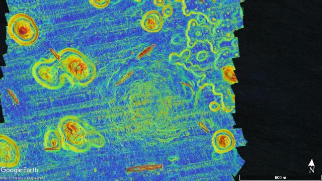
The team focused on two of the Bikini Atoll test sites from Operation Crossroads, a pair of tests the United States conducted in 1946 called Able and Baker. Able produced no visible crater, but sonar revealed that the 21-kiloton Baker test, the first ever underwater nuclear detonation, left a depression in the sea floor 800 metres across and 10 metres deep.
The data revealed a landform never before seen, a mess of scraggly ripples the researchers think originated from sediment settling on the seafloor after the test—where they have remained untouched since. They presented their data at a press session at the this year’s fall meeting of the American Geophysical Union.
Trembanis explained to Gizmodo that mapping is a “fundamental starting point for many of our scientific explorations.” This exercise expands upon diving missions to the shipwrecks in the area that scientists carried out in the 1980s and 1990s. It adds another layer to the story of the history of the early Cold War, the displacement of the atoll’s residents, and the long-lasting effects of nuclear testing more generally.
Seafloor mapping more generally is seeing a burst of interest at present. The AGU’s Eos magazine reports that 80 per cent of the seafloor remains unmapped. The Nippon Foundation-GEBCO Seabed 2030 Project aims to map the entire ocean floor by 2030. These maps could be useful for weather forecasting, navigation, and other scientific pursuits, though some worry they might be exploited be sea-mining enterprises.
Trembanis told Gizmodo that his team’s surveying time was limited, and there’s a lot more they still hope to accomplish. They’d like to map smaller targets, as well as another large crater from the Castle Bravo test that they didn’t have time to scan.