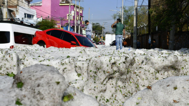
Guadalajara’s streets briefly became rivers over the last two days. A powerful storm dumped rain and hail over the central Mexico city, and when the slurry finally settled, parts of it were buried up to five feet deep in hail.
The scenes on Monday and early Tuesday as the city’s work crews dug out looked like ones that normally happen after a blizzard, save for the terra cotta roofs and palm trees as a backdrop. Cars were encased and upended in a sea of white, trees branches were snapped in half, and citizens were forced to bike, walk, or otherwise navigate hail encased roadways and footpaths.
According to the BBC, 200 homes were damaged and dozens of vehicles were washed away in the city and suburbs, which also got rocked by the storm.
The Mexican weather service warned over the weekend that “strong rain” would hit Guadalajara and the state of Jalisco as a whole. While Jalisco is no stranger to crazy summer weather, the extreme nature of this hailstorm stands out. Temperatures are expected to top out in the 80s for the rest of the week, melting out the thick mats of icy precipitation with storms this afternoon hastening the melt and potentially leading to localised flooding.
WOW!!! Extraordinary #hail accumulations in Guadalajara, #Mexico this morning 30th of June…. Video by ???? Mike Colima IG #severeweather #ExtremeWeather #worldwide pic.twitter.com/vleNl9uk4j
— WEATHER/ METEO WORLD (@StormchaserUKEU) June 30, 2019
“I’ve never seen such scenes in Guadalajara,” said Enrique Alfaro, the state’s governor, according to Al-Jazeera.
He went on to tie the event to climate change, though there’s not a lot of evidence for what will happen to hail in a changing climate let alone in Jalisco. That said, extreme precipitation events are becoming more common as the planet heats up.
The warmer the atmosphere, the more water it can hold and eventually rain (or perhaps hail) down. Conditions that can spawn severe weather are also likely to increase in a warming world. Whether this particular hailstorm is a sign of climate change is tbd, but regardless, it’s probably a good idea to prepare for more intense precipitation now and into the future.
Luego de una inusual granizada en distintas colonias del Área Metropolitana de Guadalajara, principalmente en Rancho Blanco y en la Zona Industrial, personal de Protección Civil Jalisco atendió la situación desde la madrugada. pic.twitter.com/EZ0XQhhIW6
— Enrique Alfaro (@EnriqueAlfaroR) June 30, 2019
The timing lines up with Jalisco’s wet season, which starts in June thanks the migration of a band of thunderstorms that encircles the globe known as the Intertropical Convergence Zone or ITCZ. It wobbles north and south over the course the year, finding its way over the region for the summer where it can unleash some seriously severe weather.
Hailstorms can become part of that severe weather when warm air rises and pulls up tiny water droplets with it. As those droplets rise high into the frigid atmosphere, they can become – and I swear this is the actual technical term – supercool water droplets. Eventually they freeze and start to tumble downwards before getting sucked back above the freezing line in the clouds. That fuses all the water together and voila, you have hailstones. And in Guadalajara’s case, you have a lot of them.
Check out some more images and videos below chronicling the storm and aftermath.
????????❄ Parts of #Guadalajara, Mexico remain buried under two metres of #hail after a freak storm blasted the city on Sunday.
“These are never-before-seen natural phenomena,” said state governor Enrique Alfaro. “Then we ask ourselves if #climatechange is real… it’s incredible.” pic.twitter.com/W8XT5fVQqu
— FRANCE 24 English (@France24_en) July 1, 2019
#AlMomento siguen los trabajos de remoción de hielo en las calles de la colonia Rancho Blanco con el apoyo de maquinaria pesada de nuestra dependencia, retiramos el granizo de las calles y posteriormente se depositaran en camiones de volteo. @GobiernoJalisco pic.twitter.com/su9L2ee4A9
— Protección Civil JAL (@PCJalisco) June 30, 2019