Coral reefs line shores around the world, but they’re sometimes tough to spot because well, they’re underwater. Now, a group of researchers has found that satellite imagery is capable of mapping reefs on a global scale. They’ve used the technology, along with field studies, to create the world’s most thorough coral reef atlas to date — including some of the most remote reefs on Earth.
A study describing the atlas, published in the Coral Reefs journal last week, confirm that a mapping method typically reserved for individual reefs that stretch hundreds or thousands of square kilometres can map reefs on a much larger scale.
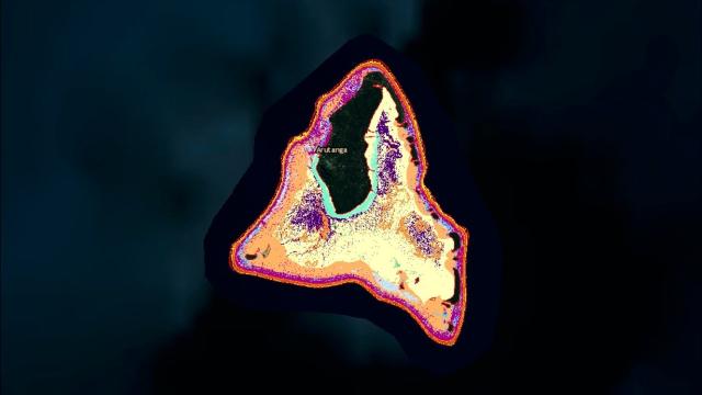
Maps such as this are key to reef conservation: Before we can figure out how to save reefs, we need to know where they are or how large they are.
Using satellites and field observations, the authors mapped more than 65,000km2 of corals. They’ve published these maps in an online database called the World Reef Map where viewers can pop into the reefs from Fiji to Seychelles. In some locations, the map offers some actual underwater footage of what the reefs look like.
Gathering all these pieces wasn’t easy. The team — whose researchers hail from the University of Miami Rosenstiel School of Marine and Atmospheric Science and Khaled bin Sultan Living Oceans Foundation, which funded exhibitions and provided the vessel to reach all the reefs — spent 10 years travelling across 11 countries to compile field information about more than a thousand coral reefs.
The authors didn’t map popular locations such as Australia’s Great Barrier Reef; they sought the most understudied reefs, said author Sam Purkis, the chair of the University of Miami’s Department of Marine Geosciences.
“We went to the most remote reefs, so mapping up the ones which we haven’t mapped should be much easier because they’re more accessible,” he told us. “We did the hard bit first.”
They sought the highest level of detail, too, going so far as to map the reefs to a single square metre using satellites. The online atlas also includes information on the surrounding habitat to provide a fuller picture of how the reefs are doing. Users can look at nearby seagrass and mangrove forest density, for instance.
While the researchers wanted to see whether satellites are a good tool for analysing reefs on a global scale, they also wanted to gather as much information about these ecosystems as possible.
“We can better monitor how they’re doing, and then we can better apply our solutions to the coral reef crisis, which might be marine protected areas or it might be reef rehabilitation or no-fishing areas,” Purkis told us. “We can make those decisions now at the global scale.”
However, using satellites to remotely assess reefs has limitations. The study showed that satellite imagery can misclassify some habitats, but the maps still saw 85 per cent accuracy.
The team was also able to double check the satellite analysis with on-the-ground observations. While they were on location, researchers analysed the corals by popping on a scuba suit and diving into the water with a video camera in hand. The team dropped more than 22,000 cameras over the course of its expedition.
The point of all this data gathering was to better prepare the next group of mappers so that they continue monitoring the world’s reefs.
All of this work comes at a critical time. Rising ocean temperatures can cause coral bleaching, which affected more than 70 per cent of the world’s corals during a bleaching event between 2014 and 2017. Acclaimed reefs such as the Great Barrier are still suffering from that event.
Meanwhile, new corals continue to be discovered. By better mapping them, scientists can gauge how they’re faring in a warmer world — and figure out how to deploy solutions to the crisis they’re facing.