A pair of fierce tropical cyclones—Cyclone Trevor and Cyclone Veronica—are poised to strike Australia on two coasts within a day of each other, prompting mass evacuations as well as official warnings of severe and dangerous weather.
A state of emergency was declared in Australia’s Northern Territory this week ahead of Trevor’s second landfall early Saturday. As the cyclone moved through the Gulf of Carpentaria, the Northern Territory saw its largest evacuation since 1974 during Cyclone Tracy, according to ABC News Australia.
Thousands of people were reportedly evacuated from areas that lay in Trevor’s path. ABC News reported that some residents of the region, including those on the island Groote Eylandt and the coastal town of Borroloola, had to be airlifted to safety.
Though #CycloneTrevor is far away from the northwest #TopEnd it is sending out waves in the wind that have triggered squally thunderstorms around #Darwin. A wet weekend is expected to continue, check your forecast at https://t.co/V0xm1HDE48 pic.twitter.com/IvNuNVmDSC
— Bureau of Meteorology, Northern Territory (@BOM_NT) March 23, 2019
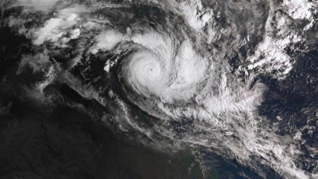
Trevor made landfall on the Northern Territory on Saturday at around 11 a.m. local time as a Category 4 cyclone, delivering dangerous winds that were felt more than 200 kilometers from the storm’s center. ABC News reporter Kristy O’Brien was situated in Borroloola when the storm struck the Northern Territory and described the system to the BBC as delivering a “guttural howling roar.”
The cyclone first made landfall on the Cape York Peninsula earlier this week, which according to the Washington Post resulted in flooding and other destruction in the area. The force of the cyclone’s first landfall was reportedly equivalent to that of a Category 3 hurricane.
The Bureau of Meteorology Northern Territory said Saturday that Cyclone Trevor had been downgraded to a tropical low system, but added that it would be delivering “dangerous conditions” and “severe weather” as it moved further inland.
The large eye of Severe #CycloneVeronica is visible on Dampier and Port Hedland radars. The system has started tracking to the southeast in the last few hours. Destructive gusts already observed SW of the centre. Sustained gales currently occuring between Karratha & Port Hedland pic.twitter.com/jvvO1dUICV
— Bureau of Meteorology, Western Australia (@BOM_WA) March 23, 2019
Tropical Cyclone Veronica, meanwhile, was nearing Western Australia’s Pilbara coast as of Sunday morning local time, bringing with it powerful and destructive winds and prompting safety warnings from the Bureau of Meteorology.
“While the destructive wind and heavy rain are the obvious impacts, this system also has the potential to bring significant storm surge and flooding to the region,” the Bureau of Meteorology Western Australia tweeted Saturday evening eastern time. “It’s worth thinking about what you would do if those threats occur.”
The government agency said it’s been more than four years since twin cyclones have pummelled Australia at once, with the last event occurring in 2015 with Cyclones Marcia and Lam.
As the Washington Post noted, the pair of cyclones arrives as Australia recently experienced its temperature average of 30.8 degrees Celcius in January. As the paper noted, warm surrounding sea waters saw above normal temperatures, a recipe for brewing tropical storms.