A lot has changed in Melbourne over the last 70 years. For one, most Victorians reading this came into existence during this period, along with new buildings, infrastructure and other landmarks. If you ever wanted to see just how different the city was in 1945, boy, do I have a surprise for you.
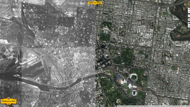
A new online map, called “Melbourne 1945”, covers the CBD and its nearby suburbs, a fair chunk of the south-east down to Frankston and parts of Werribee. You can zoom in a fair way, but not right down and a controllable slider lets you slice the screen in two — 1945 on one side and today on the other.
“Fungo_Bungaloid”, the creator of the map, provided Reddit with some background on how it came to be:
Yeah, it’s an aerial survey done in 1945, the UniMelb site has some extra information:
The 1945 photo-maps of Melbourne were produced by the Victorian Department of Lands and Survey from aerial photography taken by Adastra Airways in 1945.
Getting them to line up was the time-consuming part. The raw map sheets (80+ of them) were all roughly patched together from individual photos back in the 40s, so they don’t really stack up to modern-day standards of accuracy.
It was basically a long process of matching points on the images to points on modern day (geographically correct) imagery. Some map sheets needed up to 50 control points.
Fungo_Bungaloid goes on to say the project took over 150 hours, spread across a year. As a resident of Melbourne: thanks for your hard work! I know how I’ll be spending an hour or two today.
[Melbourne 1945, via Reddit]