The ultimate way to stay in contact with your friends while in the wilderness? This Garmin Rino 650T allows you to track each other’s positions and communicate by voice or text, outside mobile service. It’s a GPS tracker and trail guide that also lets you talk with your friends over 5km away.
AU Editor’s Note: the closest model that we can buy in Australia is Garmin’s Rino 650, which is $599. It has the same radio, GPS and texting features as the 650t. — Cam
What Is It?
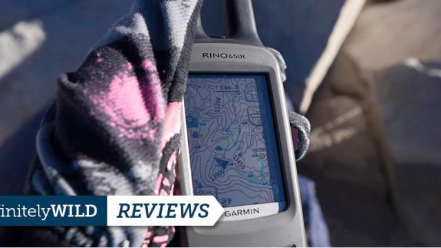
The Garmin Rino 650t is a combination handheld 5w GMRS/FRS radio and feature-packed GPS unit. This one comes preloaded with Garmin’s 100k Topo and Bird’s Eye Satellite imagery that can be loaded from your computer. When multiple Rino units communicate with each other, they begin sharing location data for each unit to the other units, making it easy to visually see where each person with a unit is.
Anyone on a group outdoors trip of any kind in which the party may separate for any reason. A hunter who wants to tell his partner where he is, where the animal is, and where he needs to go, all while remaining completely silent. The overprotective parents who want to keep tabs on their children while they run aimlessly through the woods. Boaters, climbers, hikers, fishermen, cyclists, motorcyclists, outdoors bloggers…
Had Wes and Ty been carrying these while backpacking the Lost Coast last winter, they wouldn’t have lost their friend Mat.
Just about anyone who adventures outside has used a GPS, and has at least at one point thought how convenient a radio would be when they didn’t have one.
With the double antenna horns, I can kind of see where the “Rino” name came from. The size of the Rino 650t is pretty large, but when you compare it to the 2 devices that it would otherwise be replacing, it is pretty reasonable. The screen is adequate to read the maps, but I’ve been spoiled by the 5″ display of most smartphones now, and trying to use this as a stand alone GPS units leaves me wanting the large screen of my phone. We’ve gone over how you can turn your Smartphone in a Powerful off the grid GPS device.
Because this thing is about an inch smaller than a red brick, you most likely won’t be putting it in your pocket, but will instead be using the Garmin supplied clip and carabiner. At least they knew that it was big and gave you a solution. IPX7 waterproofing provides peace of mind and adds to the overall quality build of the device.
What’s It Like To Use?
We took the pair of Rinos up Mt Whitney, the Grand Teton, and hunting in the High Sierra, testing out each of the different features. Garmin loves to tout the “glove friendly” touch screen display, which does work pretty well. What this really means is that it uses the old resistive technology of touch screens that require you to press firmly to register a touch. Garmin has done an excellent job though of tweaking this touchscreen to work more like today’s modern capacitive screens found in most every smartphone.
Multi-Day Hiking: With an expected battery life of 14 hours, you will have to choose when you want to use the device, and when to leave it off. As we were heading up Whitney, we left the radios on to test out the tracking, this came in handy when we each went up to the summit from trail camp at different times. The top photo shows Sam and me on the summit while Valerie and Courtney were still at trail camp.
NOAA weather radio is extremely useful and can be life saving. You can set up alerts to be broadcast as soon as NOAA sends them out. Setting off for the peak, but don’t see the thunder clouds rolling in beyond the mountain, this alert could save you from getting caught in a storm.
Garmin shows beautiful pictures of complete trails of you and your partners (above left), but my experience was a little more jagged (above right). We were hiking side by for most of the hike until trail camp. My unit was the blue track, and Valerie was in red. I am not sure if I was missing a setting to leave constant polling on or what, but this is pretty different.
Upon further investigation, the unit may only broadcast its location when a radio broadcast is activated. If this is truly the case, you may need to initiate a radio broadcast whenever you want your partner to know where you are. Each unit has the ability to “poll” other units manually for their location, but this seems like it should be something that is done automatically based on what the Garmin images show.
Hunting: The best feature of the Rino line of radios, when used for hunting is the “note” and wireless data sending. While you can view where your partner is, you can also send him waypoints of where you spotted an animal or type up a quick note to tell him where to go, without making any noise. You’ll have to hone your twittering skillz though, each note is capped at 13 characters.
As soon as you send a note, waypoint, or other data, it is broadcast to across the radio channel, meaning that anyone who is on that same channel will get the message. When stalking an animal, it’s usually pretty simple commands that you are trying to relay to your partner, and we found it to be extremely useful.
Range: Garmin claims a range of 20 miles with a perfectly clear line of sight, this would be like standing on the top of a mountain and talking to someone on the valley floor. To get the most out of the range, you will need to crank up the power on the device to broadcast with all 5 watts. On my first trip, I had it set at .5 watts, and range was not very good.
My hope was to test this on the Grand Teton, but the weather kept us off the summit. I did, however, get to experience some pretty surprising results when it came to range and signal. While in a mountain valley, behind a protruding rock face, I was still able to talk to Valerie who was about 4 miles away and 5,000 feet below. I would not have expected to reach her while being this deep in a canyon. Check out the above map for location during this communication, notice the contour lines of the hills and valleys.
An important thing to keep in mind, is that this device is not a SPOT, nor a satellite phone. It can only transmit over radio and is limited by line of sight. Do not expect this to be your saving grace and call for help when no-one is around.
Garmin BaseCamp is the computer software (PC/Mac) that you will use to download the BirdsEye Satellite imagery and put it onto your device. Using this software is kind of painful. When selecting an area for download, you are limited to about 230 Mb of data per area, this corresponds to roughly 360 square miles in the “High” setting of detail, and 90 square miles in the “Highest”. Downloading is painfully slow too. I have a normal high-speed internet connection and it took 30 minutes to download those 230 Mb from Garmin’s imagery servers. The only saving grace is that you can download multiple maps at one time. If you have a trip coming up, don’t plan to do this the night before. It seems odd to me to put a limit on the size that you can download, especially considering this device has 4 GB of internal storage and allows you to add an SD card for more map storage.
BaseCamp does have a bunch of features, like geotagging all of your photos by syncing the time stamp of your photo with your GPS trail.
These are all the segments of BirdsEye Imagery that I had to download to cover the area I plan to hunt. It is definitely a large area, but having to jump through hoops to get it was frustrating and time-consuming.
What’s To Like And Dislike?
Having the ability to visually see where the other person is has been extremely useful in every situation. When I was on the summit of Mt. Whitney and waiting for Valerie to make her way up, I could just look on the radio and see where she was (as long as we had made a radio call). Conversely, when I was climbing the Grand Teton, she could keep tabs on our travel and know when we were going to back.
Where this device really shines is in hunting, when you need to communicate with your hunting partner while remaining silent. The IPX7 rating means that you can drop it in a stream or use it in the rain and not worry.
It may be called the Rino because it is pretty hefty. At 11.3 ounces, and just under the size of a standard red brick, there is no casually putting this thing in your pocket. The plastic screen on the device is pretty soft and suffered a deep scratch all the way across when we were stalking through thick brush on a hunt.
The Rino has a mini-USB port on the back of it, but you cannot use that for charging. There is a separate charging port and you must use a Garmin supplied power cable that is hardwired to the power plug. You can continuously power the device with this charger, but it seems so silly that if there is a mini-USB port on the device that you cannot use that for charging it. If you wanted to recharge these in the field or use them for more than a day, you would be better off purchasing the AA battery pack for $US30 and a set of rechargeable AA batteries. I don’t think the intended user is a multi-day thru hiker, but recharging should be easier. Most people will only be using these one day at a time, so recharging each night won’t be a problem.
The included software, Basecamp is slow and clunky. One of my 2 units froze and I had to send it back to Garmin. Customer service was pretty easy to work with and sent a replacement unit within a week. The software always seems to be the Achilles heel of Garmin. As with all other Garmin products, frequent updates are required to keep the device running smoothly and the UX is, at best, frustrating.
Should You Buy It?
Do you already carry a radio and a GPS when you go outdoors? Would having a single unit lighten your load and streamline your kit?
At $US550 this device is not cheap. But compared to the price of a quality, standalone radio and GPS navigator, it may actually save you some money.
Garmin has a few other models that just differ in features. The $US600 Rino 655t has an added 5 Mp camera which does not appeal to me, I will always have a better camera on me. The Rino 650 is $US500 and basically same as the 650t, but it has only a 2-watt radio instead of 5 watts of the 650t and it does not include the BirdsEye Satellite Imagery subscription, a $US30 value per country. Unless you don’t need satellite imagery, it is kind of a no-brainer to opt for the 650t. Lastly is the Rino 610 at $US350, but it only has a 1-watt radio, and does not include the $US65 rechargeable lithium ion battery that comes installed in all the others.
Despite some of the downsides of using this unit (mostly from the computer side), I am still taking this with me on every hunting trip and relying on it when I bring it with me hiking as well. Having the peace of mind to be able to locate someone when they may not otherwise be able to communicate could potentially be life saving, as long as they are in range.