The Sahara is about the worst place on Earth to find water today, but that wasn’t always the case. Thousands of years ago, its sandy dune fields were lush and verdant. A new scientific paper helps explain why: the Western Sahara used to be irrigated by a vast river network.
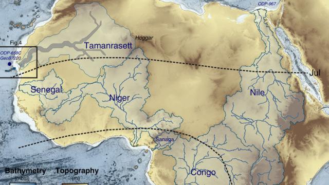
That’s the fascinating conclusion of Charlotte Skonieczny and colleagues, who used radar satellite data to map the geologic features buried beneath the Western Sahara’s sandy seas. The study, published in Nature Communications this week, reveals the traces of a drainage network some 520km in length. If still flowing today, it’d be one of the largest river basins on Earth.
We had our first hints of a Saharan river network years ago, when geologists discovered fine river sediments buried in the deep ocean off the Mauritanian coast. A few years later, another study uncovered a spectacular, 400km long canyon — dubbed the Cap Timiris Canyon — in the same region. Canyons like this are typically found off river mouths; Cap Timiris was among the first to be discovered off the coast of a desert. But until now, there was no direct evidence for a river network anywhere in the Sahara.
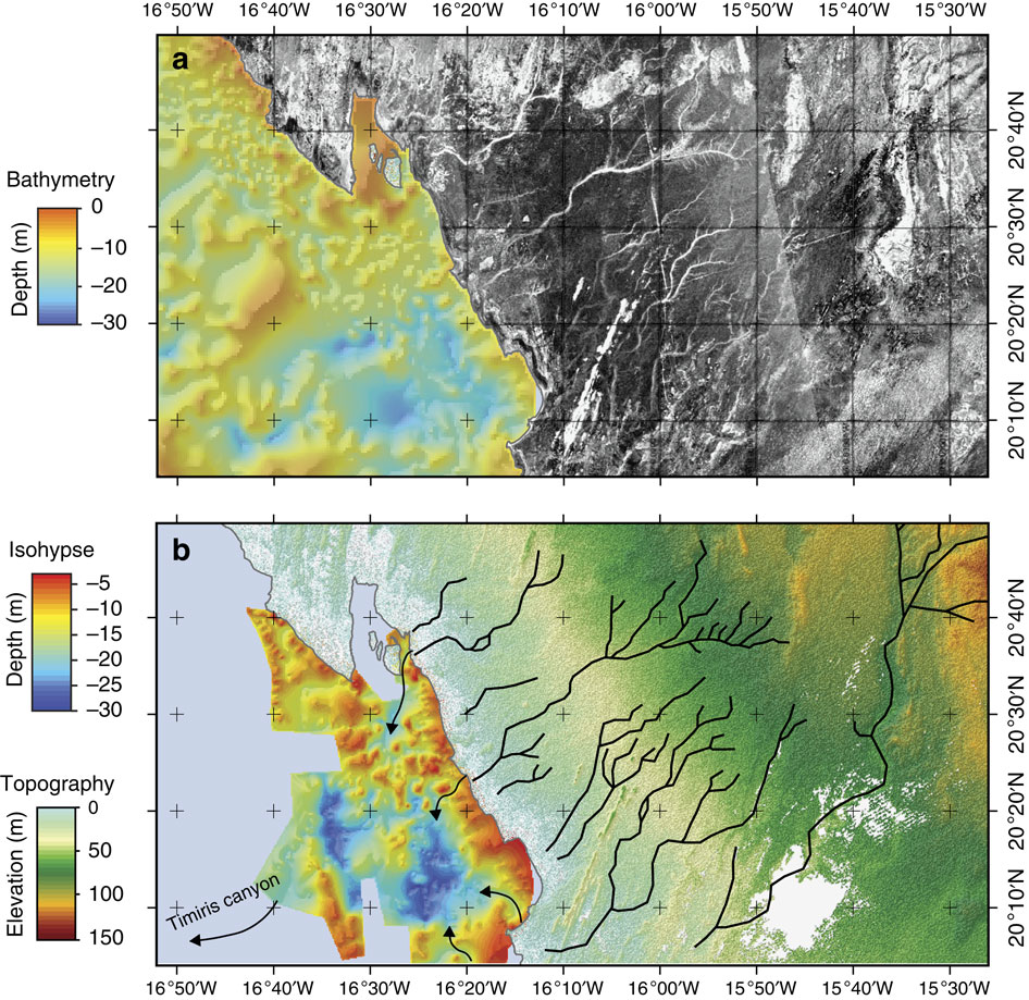
Top: Radar observation of the coastal part of the Mauritania. Botton: Coastal part of the Tamanrasett paleodrainage (black) identified by radar. A topographic map of coastal bedrock shows paleovalleys (black arrows) of the Arguin Basin. Image Credit: Skonieczny et al. 2015
But it turns out the proof was right there all along. Using satellite remote sensing data, Skonieczny and her colleagues have now traced the outlines of a large paleodrainage network, one that aligns perfectly with the Cap Timiris Canyon system. “The data presented here allow, for the first time, to establish the continuity of this past giant drainage system from the continent (Tamanrasett River) to the shelf (Arguin basin), and then to the bottom ocean (Cap Timiris Canyon),” the researchers write.
The researchers believe that the ancient Tamanrasett river wets up during African Humid Periods, climate oscillations caused by wobbles in Earth’s orbit around the Sun. During the most recent African Humid Period — which ended about 6000 years ago — humans, animals and vegetation inhabited the Western Sahara. As barren and lifeless as it is today, the world’s largest desert has had a pretty colourful history.
[Read the full scientific paper at Nature Communications]
Top: Map of the main rivers of the Mediterranean, West African Tropical and Equatorial regions of Africa. The Tamanrasett paleodrainage network across western Sahara was identified in this study. Image Credit: Skonieczny et al. 2015