At bustling traffic hubs like O’Hare International, planes can spend an interminably long time waiting for their turn to land. And at airports like Rio de Janeiro — Galeão International, pilots must contend with tight flight paths to avoid crowded population centres and hills on their final approach. But thanks to a new hyper-accurate GPS-based tracking system, airliners will no longer have to contend with land-locked navigation beacons and overworked control towers.
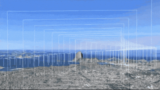
The technology is known as Required Navigation Performance (RNP). Rather than the Eisenhower-era traffic management systems and land-based radio navigation beacons we’ve been using, RNP utilises GPS satellite navigation to track planes with an accuracy of 10m and within 10 seconds of their arrival. It also demands that the planes fly along specific three-dimensional flight paths (as seen in the above GIF), resulting in a more efficient flight path for the plane, shorter flight times for travellers, reduced fuel costs for the airlines, and lower greenhouse gas emissions. Everybody wins.
RNP is more a system than any one specific piece of technology. Developed by GE Aviation, it combines software, hardware, and procedure very similar to what’s known as area navigation (RNAV, which differs in that it doesn’t require on-board performance monitoring and alerting should the pilot screw up and fly outside the lines) to ensure that all aircraft operating within a specific airspace are doing so within bounds at least 95 per cent of the time. This allows air traffic controllers to develop specific landing approaches that avoid noise-sensitive areas and geographical obstacles.
Depending on the specific topological conditions, the level of tolerance an RNP allows can vary. For example if an area has an RNP of 10, such as over oceans, all aircraft operating within that space must be able to calculate their positions within a 10 nautical mile radius. An RNP of .1, as is the case in Rio de Janiero, means they have to resolve within a tenth of a nautical mile.
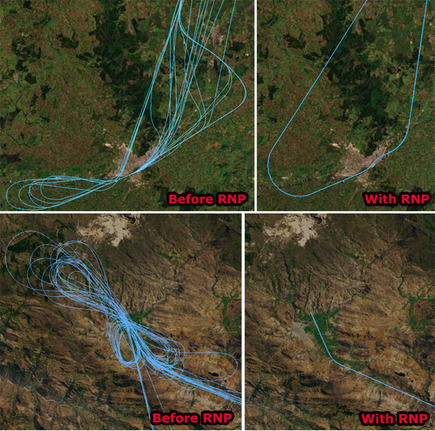
RNP technology has slowly been gaining traction at airports around the world in recent years but the pace of adoption is quickening, especially with the very real cost savings the system provides. In Brazil, which has installed the system at nearly a dozen airports around the country, planes travel 35km less and spend 7.5 fewer minutes per landing than before, translating into an estimated 735 fewer kilograms of emissions and $US24 million in operational savings over the next five years. In New Zealand’s Queenstown airport, the system reduced monthly cumulative delays from 2400 minutes to 200 minutes. In both Temuco, Chile and Cajamarca, Perú, the RNP system has drastically simplified approach patterns in these mountainous regions (see above), and in Cusco, Peru, on the slopes of Machu Picchu, the system has reduced weather-based flight cancellations by a whopping 60 per cent.

Now if only there were something we could do about the glue-sniffers running the control towers. [GE Reports 1, 2, 3 – Wikipedia – FAA – Jeppesen – AEA]