Impeachment is hardly the only thing dividing America. The weather is doing the same, cleaving the country into two distinct seasons this week.
In the West, winter arrived in full force, with heavy snow and frigid temperatures. In the East, though, a different story is underway. Record-breaking heat could roast nearly every location east of the Mississippi River for much of the remainder of the week.
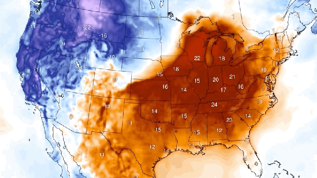
The extreme weather is being driven by a wildly contorted jet stream, a streak of air that runs west to east and generally locks in cold air to the north and warmer air to the south. Right now, the jet stream over the U.S. looks like an “S” rotated 90 degrees to the left. That’s allowing cold polar air to plunge down into the western half of the country and tropical air to drive up from the south.
The results of this atmospheric ripple are clearly visible on the ground. The Mountain West ended September with a blast of snow. Up to 120 centimetres of snow fell in Montana, with drifts climbing over houses, according to NPR.
Governor Steve Bullock called the storm “unprecedented” in his state of emergency declaration on Monday, and indeed, records for snowfall and low temperatures fell across the state. Other parts of the West were similarly buffeted by gusty winds, blowing snow, and frigid temperatures in the teens.
But if the West isn’t ready for winter, may the East is ready for summer? The jet steam contortion has sent humid air streaming into the region, offering a throwback to summer. And with the calendar turned to October, monthly records could fall in a number of locations.
In actual temperatures, large parts of the South of America could soar above 32 degrees Celsius on Thursday, the peak of the heat. Louisville, Cincinnati, Memphis and Nashville are among the locations that could set new monthly high temperature marks if the forecast comes to fruition. Even New York has a chance of hitting 32 degrees Celsius, though that wouldn’t set a record.
The kinky jet stream bringing this weather is a phenomenon that some researchers expect more of as the climate crisis worsens. It’s still an active area of research, but a growing body of papers have tied a more wavy jet steam with something called Arctic amplification.
The normally frigid Arctic region and the much warmer tropics act essentially as two hands pulling a string (in this case, the jet stream) tight. But as the Arctic rapidly warms, that loosens the tension holding the string, allowing it wobble more vigorously every time its perturbed.
This September, Arctic sea ice ” a prime indicator of Arctic warming as well as a cause of it, as the dark open ocean absorbs more heat ” hit its second lowest extent on record. That dip in sea ice and the current wild jet stream haven’t been linked together, and there’s still a whole host of work to be done on the theory. But there are definitely signs events could become more common in a warming world.
They won’t be permanent, though. And in the case of the current atmospheric contortion, the kink will work itself out in short order. That means the heat will start to recede in the U.S. Northeast after Thursday and dwindle in the Southeast through the weekend as seasonable colourful autumn ” the best of seasons ” returns to the region.