The American midwest is skipping autumn and heading right to winter to end the week.
A potentially record-setting blizzard is bearing down on the region and could dump snow from Colorado to Minnesota. The Dakotas sit near the epicentre of the storm and could see up to three feet of October snow (yes, you read that right).
Add in gusty winds and you have a recipe for life-threatening conditions. For a region that’s already dealt with one freak early season snowstorm, the latest blast of winter is hardly welcome.
Snow has already fallen across parts of the Rockies and Front Range as of Thursday late morning. Multiple accidents and pileups have been reported in the Denver metro area. Highways have been shut down as police struggle to respond amid worsening conditions.
After topping out at 27 degrees Celsius on Thursday, Denver will struggle to reach freezing on Friday. As of mid-afternoon local time, temperatures hovered at just -5 degrees Celsius with a wind chill of -10 degrees Celsius.
The chaos in Colorado is just a preview of what’s to come, though. As the storm pushes eastward, frigid air will continue to drop out of Canada and sweep across the Midwest. Along with rapidly dropping temperatures, the storm will usher in winds upwards of 100km/h and heavy snow.
Parts of North Dakota are under a blizzard warning. The worst is expected to hit mid-morning on Saturday and last through Sunday. The U.S. National Weather Service said in its warning that residents should be ready for some serious weather: “Travel should be restricted to emergencies only. If you must travel, have a winter survival kit with you. If you get stranded, stay with your vehicle.”
The cold is likely to topple record low temperatures in a number of locations while the snow could set records for October, particularly for locations in North Dakota where the heaviest snow could fall.
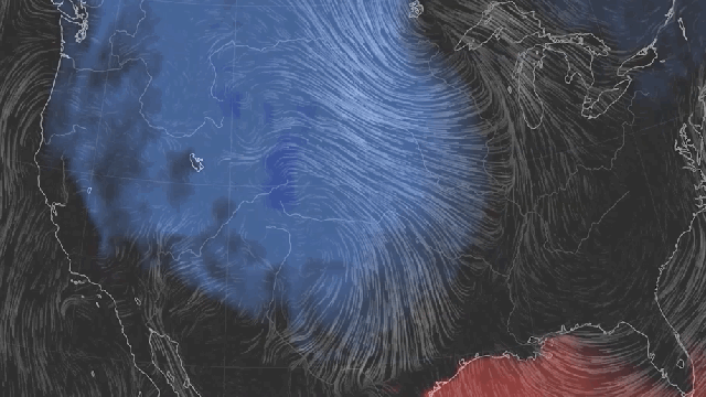
The source of the wild weather is a huge contortion in the jet stream, a rush of air that races around the world from west to east. When it’s straight, it keeps warm air locked to the south and cold air to the north. But occasionally it can get wavy, allowing cold air to drop south into its troughs and warm air to pool north under its ridges.
This week’s contortionist act in the atmosphere is what will allow the chill to drop from Canada into the Midwest. To the west of the dip, warm air is filtering up in California and the Southeast. The warmth in the Southeast is intentionally cut power.
Research indicates that a wavier jet stream could in part be driven by rapid Arctic warming. The northern tier of the planet is heating up faster than the rest of the world. That, in turn, is causing the temperature gradient that normally keeps the jet stream taut to become a little looser, allowing for wobbles in the river of air.
While nobody has done an analysis of whether this particular storm is tied to this phenomenon, researchers expect ripples in the jet stream could become more common. And with Arctic sea ice ” a key indicator of warming in the region ” just hitting its second-lowest extent on record this September, it sure fits a pattern.