The country’s midsection is about to be hit by a rare, potentially record setting bomb cyclone that will bring everything from rain to snow to hurricane-force winds and could leave severe flooding in its wake from Texas to Minnesota. So if you live in that area, listen up!
The mayhem is already beginning as moisture streams from the Pacific into the Southwest, where winter storm warnings are in effect as of Tuesday afternoon. Up to two feet of snow could fall in New Mexico’s Sangre de Cristo Mountains, accompanied by winds whipping across ridge tops at speeds of up to 75 mph, according to the National Weather Service. That alone would be pretty wild, but it’s only a precursor to Wednesday’s weather mayhem.
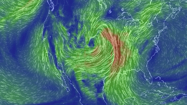
As the storm pushes inland, its pressure—which drops as storms get stronger—is expected to dip into the range of 970 millibars. That’s roughly on par with an average Category 2 Atlantic hurricane and could challenge the all-time low pressure record for Kansas. The drop will be driven by the storm’s winds as they wrap around its core in a counter clockwise direction, bringing moist, warm air from the Gulf of Mexico in contact with cold air from the Upper Midwest and Canada.
The movement of the winds is called cyclonic, and pressure is expected to drop more than 24 millibars in 24 hours, which means this storm is shaping up to fulfil the criteria for a rare inland bomb cyclone. It could even take on a hurricane-like appearance.
“The fascinating thing about this storm is how quickly it will intensify and the possible record-low pressures it will produce in the Plains,” Jason Furtado, a meteorology professor at the University of Oklahoma, told Earther. “Another neat thing is that some models are indicating that this storm will strengthen so quickly, it could develop an eye-like feature in the center of the storm. This is a very rare for non-tropical systems and even more so for storms in the central U.S.”
(It’s also rare for nor’easters, which tend to be more comma-shaped.)
Weather geekery aside, the storm is going to make a mess of things. The area facing wind gusts up to 60 mph—the equivalent of a mature tropical storm — stretches for more than 1,609km from Sturgis, South Dakota to the Texas-Mexico border. For comparison, the reach of Sandy’s tropical storm-force winds was 1,851km from edge to edge, although even that’s not a perfect comparison, since tropical storm winds start at 63km/h.
So about those winds. The most intense blasts could rip up to 75 mph in the Rockies and Southern Plains. The rotation of the storm will also create what Furtado called “a moisture pipeline straight out of the Gulf of Mexico.” That means not only will it be windy, but also snowy.
The National Weather Service is forecasting up to a foot or more of snow from Colorado to the Dakotas. Blizzard warnings are also in effect for large part of the region, and they could expand as the storm begins its onslaught.
Even after the storm clears out on Wednesday night, its impacts could linger. Aside from the heavy, blowing snow, areas on the Southern Plains could see wind-driven rain that could melt out what snowpack there is, aided by a blast of warm air on Thursday. Ed Vallee, the founder of Empire Weather, told Earther that “flooding and melting snowpack is another unique impact” could happen after the storm blows out into the Atlantic.