After two mercifully quiet months, the Atlantic hurricane season has suddenly roared to life. There are currently two storms spinning in the Atlantic basin with a potential third on the horizon.
While it isn’t like 2017’s record-setting run of storms, the sudden spate of unwelcome activity is the result of similar climate conditions. And those conditions are likely to persist for the next few weeks just as the Atlantic reaches the statistical peak of hurricane season, meaning we could see more storms spin up.
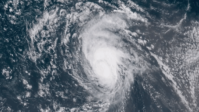
The two active storms are Tropical Storm Gordon and Hurricane Florence.
The former poses a pretty serious threat to Gulf Coast, having made landfall on Tuesday night local time with life-threatening storm surge from Louisiana to the Florida Panhandle. It could also dump up to 30cm of rain.
Florence, meanwhile, reached hurricane strength on Tuesday morning local time, though it’s expected to weaken to a tropical storm and then restrengthen to a hurricane again. It could reach Bermuda by early next week and possibly the US East Coast, but that’s still a long ways away.
Ryan Truchelut, the president and chief forecaster at WeatherTiger, told us that he’s concerned about Florence’s threat to Bermuda in the near-term, but the odds of it reaching the US East Coast are low given its track and historical precedent.
Finally, there’s a tropical wave off Africa. Waves are often precursors to tropical storm systems characterised by low pressure and thunderstorms. This one currently has a 70 per cent chance of becoming a full fledged tropical system within the next five days. What happens after that is still up in the air.
Regardless of the unnamed wave’s fate, things are definitely rumbling along after the Atlantic basin went nearly two months without a hurricane. There are two climate shifts helping stir the basin up. Or more to the point, there’s one that’s happening and one that isn’t.
The one that’s happening is the Madden-Julian Oscillation, which is characterised by a band of rainstorms that move around the equator influencing the convection of air masses in the tropics. It recently “shifted into a pattern more favourable for upward motion and tropical cyclone development in the Atlantic,” according to Bob Henson, a meteorologist with Weather Underground.
Henson noted that the Madden-Julian Oscillation could stay in its current phase for weeks, meaning we could see activity continue. This is particularly true since mid-September is the statistical peak of hurricane season in the Atlantic basin.
Then there’s the climate shift that isn’t happening. The National Oceanic and Atmospheric Administration has had an El Niño watch in place since June. El Niño is characterised by a warming of eastern tropical Pacific that in turn impacts the atmosphere. One of those impacts is increased upper level winds blowing into the Atlantic that can rip apart hurricanes or inhibit them from forming.
“[T]he progress toward that predicted El Niño event has stalled over the last month, so the potential suppressive effects on the Atlantic tropics aren’t increasing,” Henson said. He also noted that trade winds in the Atlantic are weaker than normal right now, making life easier still for tropical storms to spin up.
A third factor is temperatures in the main development region, the area of the tropical Atlantic where hurricanes traditionally form. For nearly all of hurricane season, temperatures in this region have been cooler than normal by roughly 0.5 to 1C — enough to slow down convection and deprive storms of humid fuel.
Since bottoming out in late July, though, ocean temperatures in the main development region have been steadily increasing.
“Recently, sea surface temperatures in the main development region have returned to near-normal levels,” Allison Wing, a hurricane researcher at Florida State, told Earther.
All of these conditions are likely to continue to grip the region over the next few weeks, meaning that even in a hurricane season forecast to be quieter than normal, things could get active. Truchelut worries that any storms forming after Florence could be more problematic for the US, particularly with the way a ridge of high pressure is expected to build in the coming weeks.
“I am more concerned about the waves following Florence, particularly if they are slower to develop and thus travel westward rather than west-northwestward for an extended period of time,” he said.
“The broad ridge that ensembles suggest will be in place over the east-central US for at least 11-15 days is a dangerous steering pattern that is capable of moving storms that reach the Lesser Antilles towards Florida and the Gulf Coast.”
In other words, pay attention to the forecast.