The 2017 Atlantic hurricane season was brutal, featuring strong weather systems that morphed into severe and treacherous hurricanes in a remarkably short period of time. This phenomenon, known as rapid intensification, is now happening with greater ferocity than it did three decades ago, according to new research.
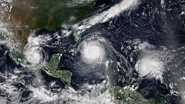
Hurricanes Irma (centre) and Jose (right) are examples of hurricanes that experience rapid intensification. Image: NOAA
With the names Harvey, Irma, Jose and Maria now indelibly etched into our memories, scientists are now seeking to understand the reasons behind their rapid growth, and whether the pace at which they accumulated their strength is indicative of a larger trend.
New research published today in Geophysical Research Letters presents evidence showing that a subset of hurricanes, namely those that undergo rapid intensification, are now doing so at rate that’s faster and with greater strength compared with 30 years ago.
For the study, researchers with the US Department of Energy’s Pacific Northwest National Laboratory (NNLN) and the National Oceanic and Atmospheric Administration (NOAA) looked into a hurricane-building process known as rapid intensification. This weather phenomenon happens within strong storms when maximum wind speed inside a hurricane increases by at least 25 knots (46.4 km/h) within a 24-hour period.
PNNL researchers Karthik Balaguru and Ruby Leung, with the help of Greg Foltz from NOAA, looked at 30 years’ worth of satellite hurricane data from 1986 through 2015, as well as data collected by NOAA’s National Hurricane Center and the US Navy’s Joint Typhoon Warning Center.
Analysis of this data shows that rapid intensification is not happening more often these days, as related studies have already suggested. What has changed, however, is that powerful storms are gaining strength more quickly within the 24-hour rapid-intensification periods than they did 30 years ago – and to a significant degree.
As noted in the study, the average increase in wind speed during this phase is now roughly 21km/h stronger than it was in the 1980s, increasing, on average, about 7.5 km/h over the course of each of the three decades studied.
So what’s changed? The researchers point to a climate cycle known as Atlantic Multidecadal Oscillation, or AMO. This system affects key sea conditions that bolster a hurricane’s strength, including (and especially) water temperature and wind shear. The AMO is somewhat of an enigma in terms of its underlying causes, but it operates in cycles lasting 10 or more years, and it regulates the amount of heat that’s available at the ocean surface.
The AMO is now affecting the sea environment in some profound ways, inducing warmer surface water, and reducing the amount of wind shear – both of which fuel the rise of powerful hurricanes.
In the past, the AMO primarily influenced the growth of hurricanes in the western Atlantic, but since the 1990s it’s been affecting storms in the central and eastern Atlantic, especially the areas around the Virgin Islands and Saint Kitts. This just happens to be the same area in which hurricanes Irma, Jose and Maria experienced their intense growth spurts last year.
As a final note, the effects of climate change were outside the scope of the study, but the authors said it should be a growing concern for meteorologists and climatologists who study hurricanes.
“Most of the increase in rapid intensification that we observed can be attributed to the Atlantic Multidecadal Oscillation, a natural climate phenomenon,” Balaguru told Gizmodo.
“Although the influence of climate change cannot be totally ruled out, it may not have played a major role. To address this, we analysed output from 16 different climate models. We found that the signatures of climate change are not consistent with observed changes in wind shear. On the other hand, changes in the Atlantic hurricane environment are highly consistent with a positive shift in the AMO.”
Looking ahead, Balaguru said more studies are needed to understand where the AMO is going, whether it will continue in the positive phase or start switching signs. Also, further work is required to separate the natural signature of the AMO from that of climate change.