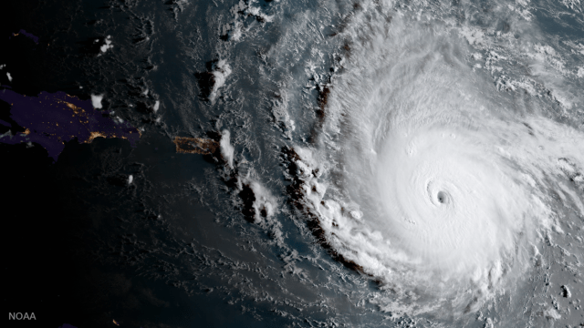
Meteorologists were at a loss for words yesterday as Hurricane Irma intensified into a enormous, record-smashing Category 5. Packing “catastrophic” and “life-threatening” winds of 300km/h, the storm now bearing down on Puerto Rico and the US Virgin islands is officially the strongest Atlantic hurricane ever recorded north of the Caribbean and east of Florida. But how did it get to be such a monster?
NOAA’s GOES-16 satellite captured this image of Irma approaching Puerto Rico. Image: NOAA
A combination of factors seem to be responsible, starting with heat. Hurricanes draw their energy from the ocean, with hotter sea surface temperatures providing the fuel for wetter, more powerful, more rapidly-intensify storms. Right now, sea surface temperatures across the equatorial Atlantic are running up to about 0.8C hotter than usual — not to mention it’s late summer, so the ocean is hot, period. “The tropical Atlantic has been warmer in some years than it is now, but it’s certainly pretty toasty out there right now too,” said Phil Klotzbach, a tropical storm expert at Colorado State University, adding that “it’s too early to say conclusively” that those extra-hot waters are climate change related.
Other experts are suggesting climate change is at least partially responsible for the storm’s heat-fuelled ferocity. As with Harvey, this linkage will no doubt continue to be a subject of investigation within scientific circles for months if not years to come.
Image: NOAA via Phil Klotzbach
But, you can have hot sea surface temperatures and still not get monster storms like Irma. Klotzbach says that low vertical wind shear, the change in wind direction with the height of the atmosphere, has also played a role; high wind shear tends to prevent hurricanes from gaining strength. Exceptionally high levels of moisture from the surface to the mid levels of the storm’s atmosphere are also providing fuel galore for thunderstorms, the building blocks of hurricanes.
Lastly, there’s the matter of location. Irma originated near the Cape Verde islands, off the northwestern coast of Africa. As NOAA research meteorologist Neal Dorst told Live Science, Cape Verde storms have the potential to become supercharged, because of the long trek they make across the equatorial Atlantic before running into land and weakening. And indeed, Irma is already incredibly long-lived — it’s been a storm for over a week, and is expected to continue packing Category 4 or 5 windspeeds until the weekend.
The only Atlantic hurricane whose windspeeds have topped Irma’s, Hurricane Allen (1980), also got its start around Cape Verde. That said, powerful storms can form just about anywhere under the right conditions, Dorst told Live Science. The last two Atlantic hurricanes to have clocked 300km/h winds were Wilma (2005) and Gilbert (1988), and both of those storms originated much further west.
The long and short of it is that, thanks to a variety of factors, the Caribbean and Florida are now facing an exceptional and exceptionally dangerous storm. The conditions for Category 5 hurricanes occur in the tropical Atlantic every year, but we’re lucky storms like this one do not. Unfortunately, it’s hard to say whether they will remain a rarity in the future.