The extremely dangerous Hurricane Matthew continues to barrel north, with the centre of the storm expected to approach southwestern Haiti by later today. The National Hurricane Center’s latest bulletin calls Matthew “life threatening”, and forecasters are making dire predictions about the how much damage Caribbean nations might suffer.
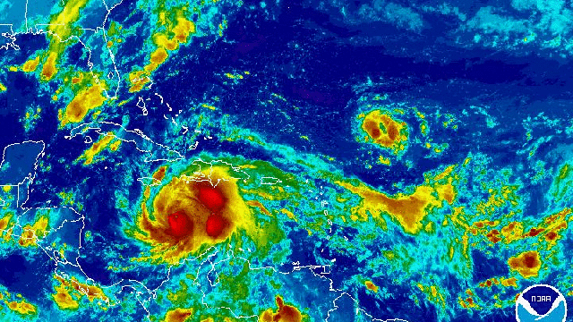
Latest GOES satellite image of the Carribbea, with enormous hurricane Matthew churning toward populated regions. Image: NOAA
Hurricane Matthew intensified rapidly on Saturday, reaching Category 3, then 4, then 5 status in a matter of hours, and becoming the strongest Atlantic tropical storm since 2007. The hurricane has since cooled back off to a Category 4, which is to say, still a very dangerous cyclone packing 220km/h sustained winds with even stronger gusts. Parts of Jamaica are already being swamped by the storm, which was centred some 330km south of Kingston as of 2:00AM AEST.
Given Matthew’s current speed and track — moving northward at approximately 9km/h — tropical storm conditions are expected to reach Haiti later this morning, with full-on hurricane weather unleashing a torrent over the southwest coast later this afternoon. The storm is then predicted to gain speed, approaching eastern Cuba tomorrow morning and the Bahamas by Wednesday afternoon Australia time. While some fluctuations in intensity may occur, the NHC advises that Matthew will likely remain a powerful Category 4 hurricane through mid-week.
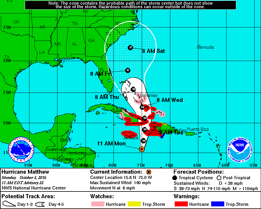
Image: National Hurricane Center
Matthew’s impact on the Caribbean is looking more severe by the hour, particularly in Haiti and the southwest Dominican Republic, where as much as 102cm of rainfall could trigger “life threatening flash floods and mudslides.” Rip-roaring winds and “large and destructive waves” will add to the danger, especially along the southern coasts and Haiti and Cuba, where water levels could swell 3.35m above the high tide line.
“It’s undoubtedly Haiti,” Weather Underground meteorologist Jeff Masters told Gizmodo when asked which nations are going to see the worst impacts. According to Masters, Haiti is particularly vulnerable due to environmental degradation, which has left the land stripped of trees and extremely prone to erosion. “The risk is Haiti is also greater due to poverty — you’ve got 50,000 people who have been living outdoors [since the 2010 earthquake].” he said.
The Bahamas are expected to get hammered hard by mid-week, with storm surges of up to 4.5m feet predicted in the latest NHC forecast. Impacts on the United States remain highly uncertain, but according to Masters, Florida, North Carolina and New England could all see heavy rainfall. “Right now, the greatest risk is for North Carolina, but that could change,” he said. “The only thing we’re sure of as far as the US goes is that we’ll see a lot of pounding waves hitting the entire east coast.”
In the Caribbean, governments and international aid organisations are scrambling to make last-minute preparations. USA Today reports that the Haitian Civil Protection agency has opened 576 temporary shelters, while the US Agency for International Development has deployed disaster response teams to both Haiti and Jamaica. But with storm’s outer bands already drenching Jamaica, the south coast of Haiti and the Dominican Republic, time is running out. “Preparations to protect life and property should be rushed to completion,” the NHC said.