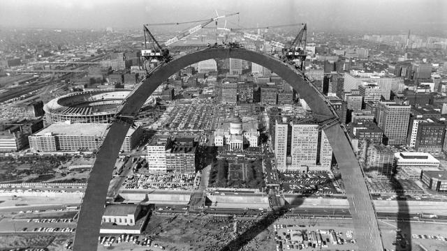
Today is the 50th anniversary of the completion of the Gateway Arch, one of the most striking and distinctive monuments in human history. But like all feats of engineering, the Arch came with a price — the obliteration of one of St. Louis’s oldest neighbourhoods.
I admit, as a native of St. Louis, I hadn’t thought much about this part until recently. But as I began to gather photos of the Arch’s construction, I found some incredible before-and-after images showing the neighbourhood that had been decimated to make room for what was thought at the time to be a shimmering symbol of progress.
We gained the Arch, and lost everything else that makes a city, a city. pic.twitter.com/AgDYQPVn0y
— nextSTL.com (@nextSTL) October 27, 2015
In the early 1900s, St. Louis’s riverfront was a bustling area of commerce, featuring some of the oldest buildings in the city (although some had been rebuilt after a big 1849 fire) and a large African American population. But the neighbourhood had also become home to some unsavoury pursuits, and some politicians were all too eager to knock it down.
In 1935 a controversial vote (with accusations of fraud) ended up passing, wiping the slate clean for a glittering new park. In 1939 the mayor swung a crowbar at the first of the 486 structures cleared. The land then sat empty for almost two decades.
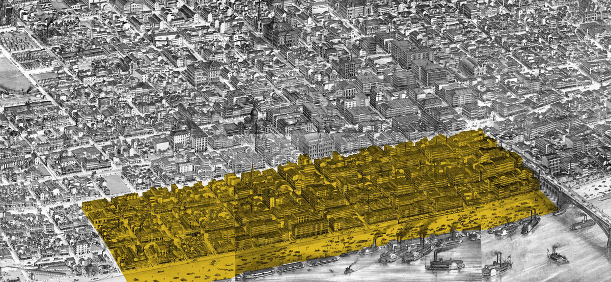
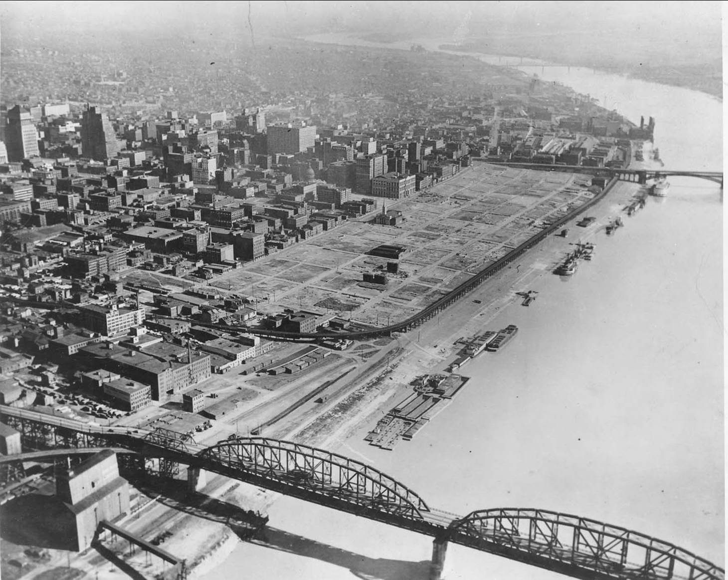
Images of St. Louis’s riverfront from 1875 and the 1940s via Framing a Modern Mess
Why did so many buildings get torn down for what appears to be a very slender structure with a light footprint? It wasn’t just for the Arch and its museum (which is actually underground). There were also parklands which promised to provide an expansive greenway along the Mississippi River. But although many visitors come to see the Arch and ride up in its bizarre space capsule-like elevators, the park and the riverfront never really ended up becoming the destination that the city had hoped. I remember attending festivals on the expansive green grass as a kid. But I walked along the river a few years ago and was disheartened at how empty it was on a Friday night.
It’s not just the Arch that’s to blame, I should note. In the NextSTL.com tweet above you’ll see the freeway slicing the Arch off from downtown itself. The construction of this canyon-like highway ended up displacing even more residents from the area. This poor public space planning, combined with poor transportation planning, pretty much builds an impermeable wall between the St. Louis’s downtown and its river. Yes, the Arch is beautiful, a point of pride for the city. But it ended up creating barriers instead of making connections.
Since the Arch was built, the city has struggled with a dwindling urban population, and, as we’ve witnessed over the last few years, tremendous racial inequality. I keep looking at those photos and wondering: Could the Arch actually be have been responsible for downtown St. Louis’s downfall? Is it the reason that East St. Louis, just over the river, doesn’t feel connected to the rest of the city?
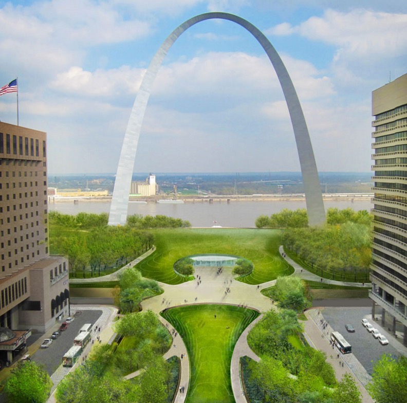
When you go to the Arch now you’ll see a very different scene. There’s construction again, but this time it’s hoping to repair the damage and knit the city’s downtown back to its river. The CityArchRiver project, which broke ground earlier this year, features a park being built over the highway, a greenway that extends through the center of downtown, and a plan to reconnect both riverbanks. In addition, there’s a proposal to reroute I-70 entirely so it no longer cuts through downtown.
I don’t blame St. Louis for what happened. Like most urban redevelopment projects of the same era, the city was simply doing what it thought was right at the time. Clearing crowded neighbourhoods to build brand-new housing. Adding freeways to help get more car-owning citizens to their jobs. But we now know all those decisions ended up tearing gashes in our cities, removing pieces of the community that we might never get back.
The attempt to right the misguided decisions of 50 years ago is happening in almost every city in the US right now — it’s happening right here in LA, where I live now — but I think that St. Louis has one of the most symbolic journeys. No one can disagree that Eero Saarinen’s silver swoosh helped to put this city on the map. Now St. Louis can use that fame to show other cities how urban revitalisation can be done right.