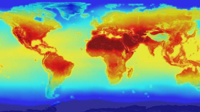
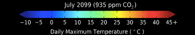
The image you’re looking at is a glimpse into our future. Welcome to July 2099, according to 21 different climate models. CO2 concentrations have topped 900 parts per million, comprising nearly one per cent of our atmosphere. (In early 2015, we hit 400).
The predictions shown in this daily max temperature map come from a new NASA dataset released to the public on June 9th, one that collates historical records and climate models to produce high-resolution forecasts for the end of the century. Hosted by NASA Earth Exchange (NEX), the data, which can be filtered down to the level of individual cities and towns on a daily timescale, will help developing nations predict and prepare for the local effects changing patterns in weather, floods and droughts. At a global scale, it will help Earth scientists, and anyone else who’s interested, explore what’s looking to be a very toasty end of the century.
“NASA is in the business of taking what we’ve learned about our planet from space and creating new products that help us all safeguard our future,” said Ellen Stofan, NASA chief scientist. “With this new global dataset, people around the world have a valuable new tool to use in planning how to cope with a warming planet.”
According to NASA:
This NASA dataset integrates actual measurements from around the world with data from climate simulations created by the international Fifth Coupled Model Intercomparison Project. These climate simulations used the best physical models of the climate system available to provide forecasts of what the global climate might look like under two different greenhouse gas emissions scenarios: a “business as usual” scenario based on current trends and an “extreme case” with a significant increase in emissions.
The NASA climate projections provide a detailed view of future temperature and precipitation patterns around the world at a 15.5 mile (25 kilometer) resolution, covering the time period from 1950 to 2100. The 11-terabyte dataset provides daily estimates of maximum and minimum temperatures and precipitation over the entire globe.
NEX, whose data and analysis tools are freely available through the OpenNEX project on Amazon Web Services, is a great example of how scientific knowledge can be shared with the public, allowing anyone to explore and analyse the most current climate predictions to date, run and share models. You can download the new dataset here, and learn more about OpenNEX here.
[NASA]