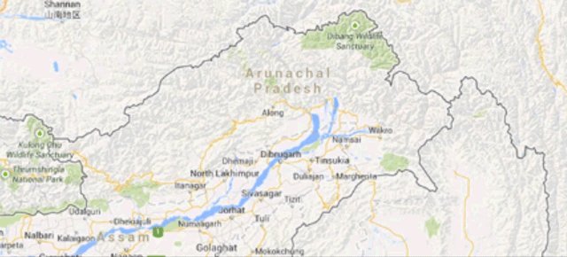
Border disputes are still going on in a bunch of places around the world. That makes life difficult for mapmakers, and especially difficult for the world’s favourite online map service, Google Maps. As The Washington Post points out, Google strives to not get stuck in the middle of a territorial struggle, by showing you the border you most likely want to see based on where you’re Googling from.
Shown above, two different views of Arunachal Pradesh, a territory claimed by both China and India. As The Washington Post‘s Adam Taylor explains, Google India shows the border that makes the territory part of India, while Chinese Google shows the border claimed by China’s government.
Google Maps does a similar diplomatic dance for other controversial regions, for example referring to either the Persian Gulf or the Arabian Gulf depending on which nation’s Google you’re using.
So far, Google Maps still shows Crimea as part of Ukraine on both Ukrainian and Russian searches. With tensions over the region mounting, will Google Maps tiptoe along the line of neutrality and show Russia’s supporters what they want to see? I guess we’ll just have to keep Googling to find out. [The Washington Post]
Picture: Nicholas Stango