You’re looking at a satellite image of the Dasht-e Lut salt desert in southeast Iran. If you think it looks a bit weird, that’ because it is: it’s widely regarded as the hottest place on Earth.
The highest land surface temperature ever recorded — from space, by satellites — was in the Lut Desert back in 2005. It reached a staggering 70.7C. That is off the wall.
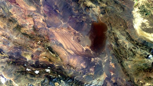
So, what can you see in the picture? The European Space Agency explains:
The light area in the centre of the image are the long, parallel wind-carved ridges and furrows. The darker area to the east is an extent of massive sand dunes, some reaching up to 300 m tall. In the upper-right section we can see a light green, shallow body of water that straddles Iran’s border with Afghanistan… In the lower-left we can see the white, snow-capped Jebal Barez mountains.
The image was captured by Envisat’s MERIS instrument. And is a welcome reminder that we shouldn’t grumble about the weather. [ESA]