The East River? Oh, that thing was dammed up and a new City Hall was thrown on top of it. The Hudson? Filled it with traffic years ago. New Yorkers have never been prudes about changing the natural landscape of their city, but if you dig into the archives, you’ll find dozens of ideas so radical, they make present-day Gotham feel like a nature reserve.
These days, the ballooning cost of construction combined with environmental and preservation issues conspire to make extreme infrastructural projects a moot point. Hell, it’s taken almost a century to build the 2nd Avenue Subway. But in the middle of the 20th century, a booming economy and a renaissance in public infrastructure made it seem like anything was possible in New York — literally, anything.
Six plans from those years follow, ranging from the grand to the gargantuan. Makes Bloomberg’s Vision 2020 plan look a bit puny in comparison, no?
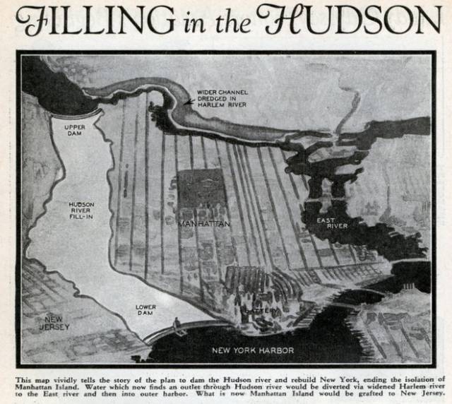
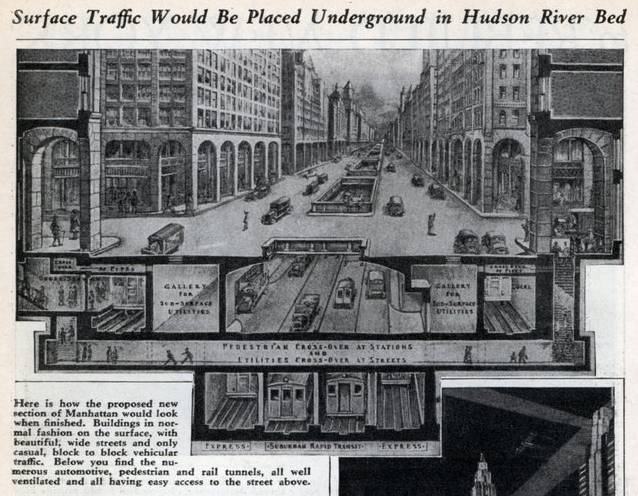
Infill the Hudson River, 1934
In March, 1934, Modern Mechanix featured the daring plan of Norman Sper, “noted publicist and engineering scholar” (maybe publicist meant something different back then?), who envisioned adding 26sqkm of land to Manhattan by infilling the mighty Hudson River. Sper proposed creating a massive, multi-layered grid that would connect New Jersey to Manhattan, solving problems like housing and transit which, according to the editors, “are threatening to devour the city’s civilisation like a Frankenstein monster”.
It’s hard for us to imagine the optimism felt about modern engineering in the 1930s and ’40s. Today, Sper’s plan seems like folly. But the magazine asked a handful of established engineers about it, and many of them described it as visionary. “Provided with sufficient money and time, particularly money, the project could be carried through to completion with unquestionable success,” said one engineer. “…It would be quite in keeping with President Roosevelt’s rehabilitation and N.R.A. plan and put an enormous army of men to work. I heartily endorse the plan, though I am fully aware of the almost insurmountable impediments which appear at first study of the idea.”
Estimated cost: $US17 billion*
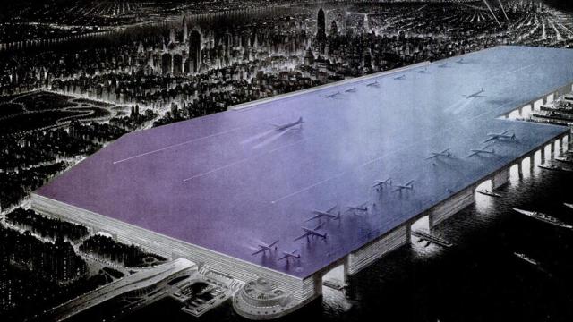
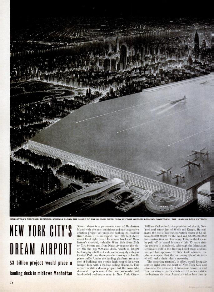
Build a Massive Hudson River Airport, 1946
The man who owned the Chrysler Building — William Zeckendorf — was behind this idea to build “Manhattan’s Dream Airport.” Zeckendorf proposed a 144-block-long floating airport on the edge of the Hudson River, where planes could take off on the long roof and boats could dock at its edges.
It’s hard to know how New Yorkers of the day reacted to the plan, which was sited on the edge of what was then a still-developing neighbourhood. But as Untapped Cities points out, a similar (but satirical) plan to turn Central Park into an airport received over 85,000 earnest signatures — which should tell you something about how “green space” stacks up against “long cab rides” for most modern-day New Yorkers.
Estimated cost: $US35 billion*
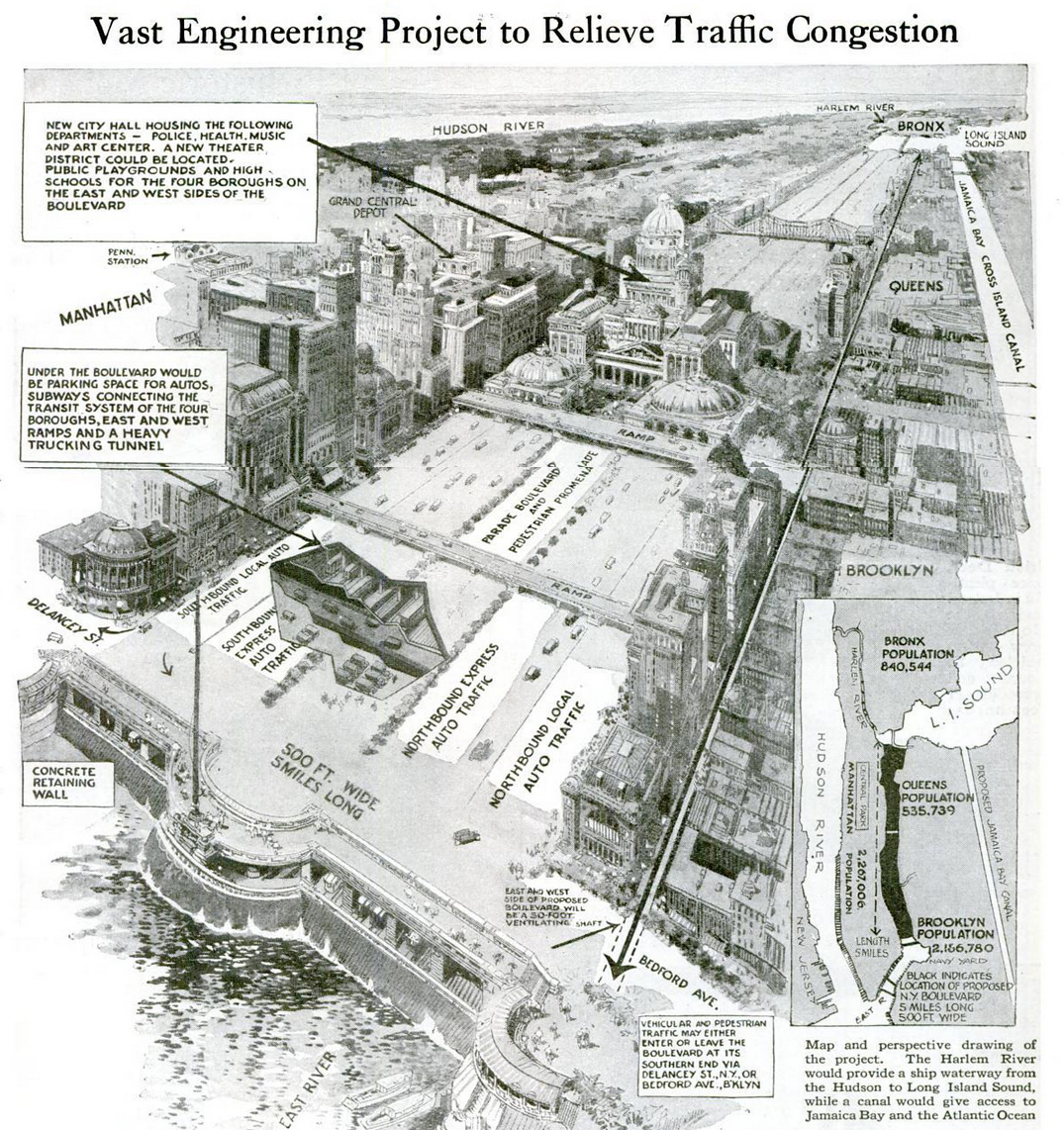
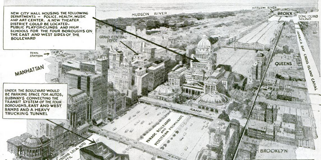
Draining the East River, 1924
According to the editors at Popular Science, in 1924, New York was loosing $US1.5 million a day on traffic congestion. The solution? Get rid of the East River, of course. Dr John A. Harriss, a “special deputy police commissioner in charge of traffic,” was the progenitor of this particular scheme, which would’ve required the construction of two dams — one at the Williamsburg Bridge, the other near Hell Gate in Harlem. In between, Harriss envisioned a broad avenue of cars and small pedestrian routes, centred by a massive new City Hall. Basically, Brasilia in New York City.
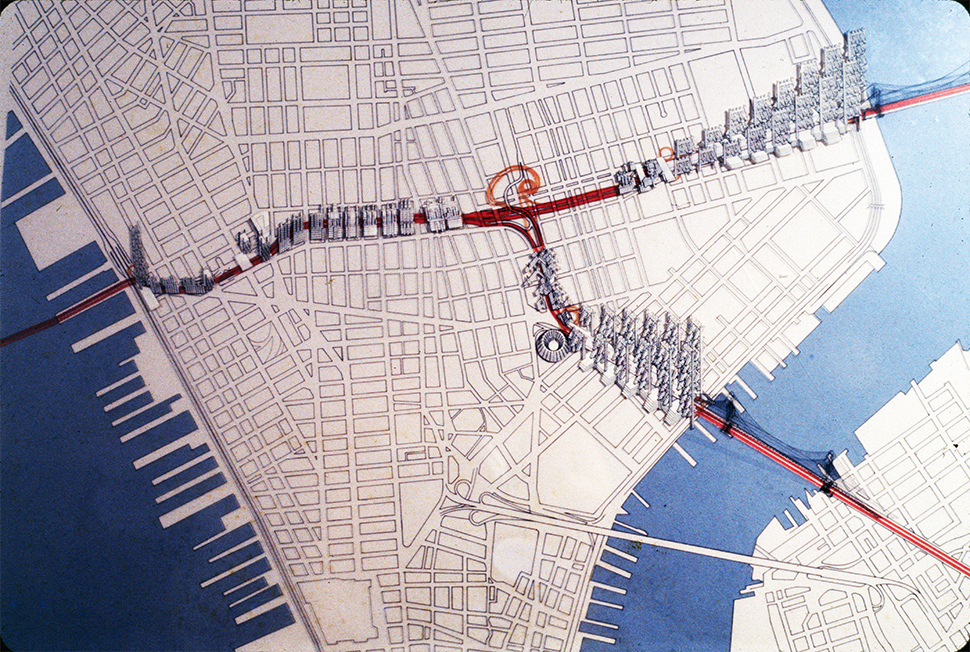
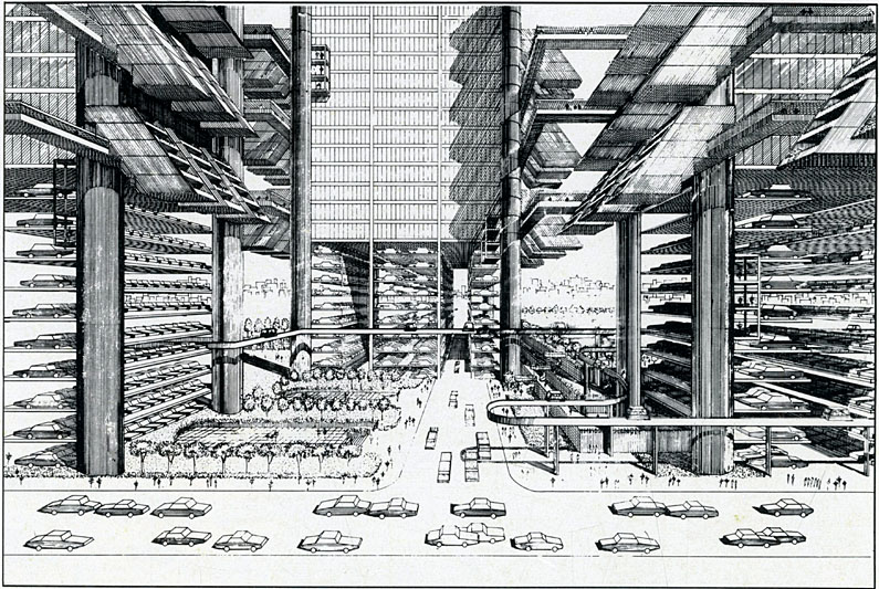
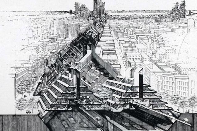
A Super-Highway Slicing Through SoHo, 1940-1962
The mercifully unfulfilled Lower Manhattan Expressway was one of Robert Moses’ plans to modernise Manhattan. LOMEX, as the plan is known, came close to levelling a huge 14-block swatch of Lower Manhattan to build a 10-lane highway stretching from the Holland Tunnel to the Manhattan and Williamsburg Bridges. Moses envisioned the highway edged on both side by gigantic public housing complexes.
We actually have LOMEX (along with the destruction of Penn Station) to thank for the development of historic preservation in New York City. Jane Jacobs led the fight against the project, and ultimately, it was abandoned. It’s hard to imagine that anyone ever seriously entertained the idea — but we need only look across the East River to see what could have been, since Moses was central in creating the Brooklyn-Queens Expressway, the highway that required the razing of thousands of homes in each borough.
Estimated cost: $US749 million*
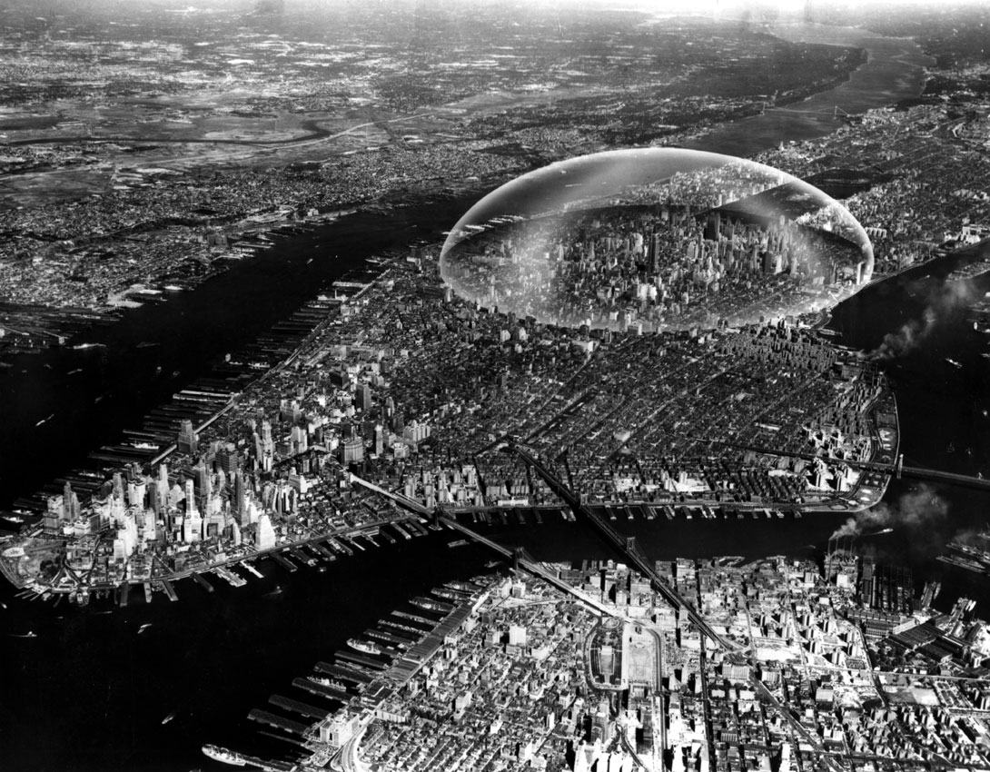
A Geodesic Dome Over Midtown Manhattan, 1960.
Buckminster Fuller’s geodesic dome was proposed with the best intentions: It would have created a bubble of clear air stretching from the Hudson to the East River, between 21st St and roughly 64th St. Of course, in reality, it likely would’ve led to strict urban segregation in Manhattan, between those “inside the bubble” and those without.
Estimated cost: $7.5 billion*
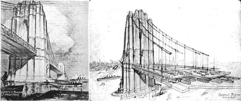
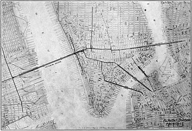
A Bridge Over the Hudson, circa 1915
Ever wonder why there are no bridges between Lower Manhattan and New Jersey? One of the main reasons is that too many massive freighter ships passed through the bay on their way to Manhattan’s docks. But architect Alfred C. Bossom envisioned a seemingly simple solution: A bridge 200 feet above the waterline, more than enough space for ships of the day to pass unfettered.
Bossom christened his idea the Victory Bridge, angled as a celebration of the end of World War I. The concept never took of, perhaps because of the sheer size and cost (the towers themselves would’ve been more than 800 feet high), but Bossom was right on, in some ways: The Holland Tunnel was completed underneath the exact same route, in 1927.
*All estimated costs have been adjusted for inflation.
It’s the most popular NBN speed in Australia for a reason. Here are the cheapest plans available.
At Gizmodo, we independently select and write about stuff we love and think you'll like too. We have affiliate and advertising partnerships, which means we may collect a share of sales or other compensation from the links on this page. BTW – prices are accurate and items in stock at the time of posting.