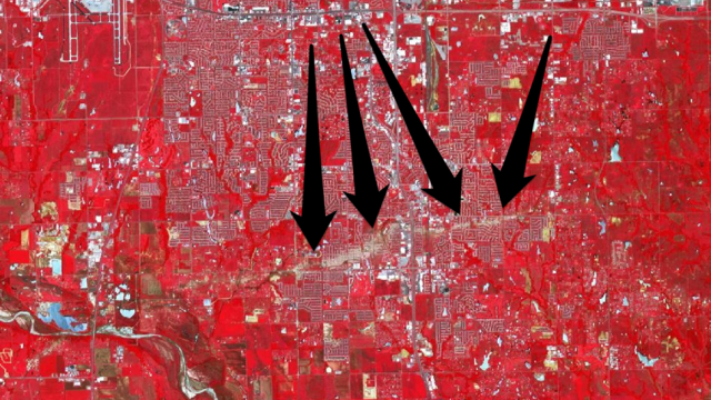
On May 20, the Newcastle-Moore tornado tore across central Oklahoma for 39 minutes, killing 24 people and causing an estimated $US2 billion in damage. The NASA image above shows the 27km tract of scraped earth the disaster left in its wake in striking relief..
At its widest, the Newcastle-Moore tornado was 2km wide — so wide that you can see its path in beige on the false-colour image above, which was captured by the Advanced Spaceborne Thermal Emission and Reflection Radiometer aboard NASA’s Terra satellite. Here’s what you’re looking at, according to NASA:
…Infrared, red, and green wavelengths of light have been combined to better distinguish between water, vegetation, bare ground, and human developments. Water is blue. Buildings and paved surfaces are blue-gray. Vegetation is red. The tornado track appears as a beige stripe running west to east across this image; the colour reveals the lack of vegetation in the wake of the storm.
Leave it to NASA to make something horrible look positively beautiful. Our thoughts are with everyone affected by the disaster. [Nasa]
