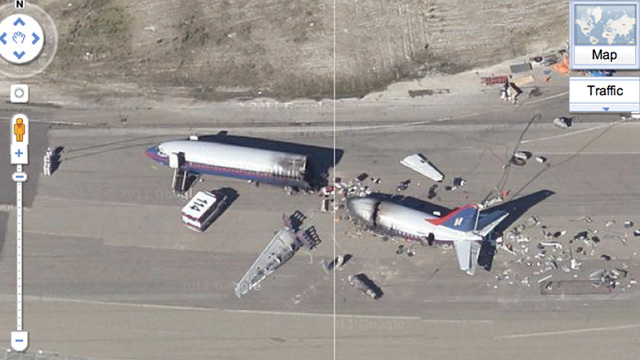
Follow this link to a Google Maps shot of Alameda, California, and you’ll see an arresting site: a downed commercial aircraft spewing debris, with its wings snapped into pieces and its hull cut cleanly in half. It looks like a crash perfect enough for a TV show. And in fact that’s just what it was.
Google Maps Mania sets the record straight on the real fake plane crash:
Google Maps aerial view has got some great shots of a simulated plane crash that was created for the television series Trauma. The mock airliner crash was filmed on the runway of the former Navy base at Alameda Point.
A Boeing airliner was used as the mock-up of the crashed plane. I think the episode was filmed in 2009. Google’s aerial view imagery of the area was released at the end of 2009, so I assume the imagery was gathered at some point during that year.
And here’s that very crash. Very cool. And Alameda Point happens to be the same air field where they film some Mythbusters episodes, so who knows, maybe an ant-sized Adam Savage is lurking somewhere on Google Maps a few clicks away. [Google Maps, Google Maps Mania via Reddit]